You are here: Home > Network List > CI - Caltech Regional Seismic Network Stations List
> Station MPM Manuel Prospect Mine, California, USA > Earthquake Result Viewer
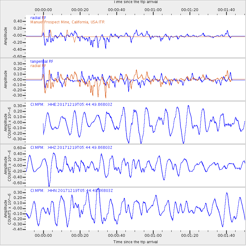
MPM Manuel Prospect Mine, California, USA - Earthquake Result Viewer
*The percent match for this event was below the threshold and hence no stack was calculated.
| Earthquake location: |
Southern East Pacific Rise |
| Earthquake latitude/longitude: |
-21.9/-114.2 |
| Earthquake time(UTC): |
2017/12/19 (353) 05:35:29 GMT |
| Earthquake Depth: |
10 km |
| Earthquake Magnitude: |
5.6 mb |
| Earthquake Catalog/Contributor: |
NEIC PDE/us |
|
| Network: |
CI Caltech Regional Seismic Network |
| Station: |
MPM Manuel Prospect Mine, California, USA |
| Lat/Lon: |
36.06 N/117.49 W |
| Elevation: |
185 m |
|
| Distance: |
57.7 deg |
| Az: |
356.896 deg |
| Baz: |
176.443 deg |
| Ray Param: |
$rayparam |
*The percent match for this event was below the threshold and hence was not used in the summary stack. |
|
| Radial Match: |
55.607597 % |
| Radial Bump: |
400 |
| Transverse Match: |
51.68969 % |
| Transverse Bump: |
380 |
| SOD ConfigId: |
13570011 |
| Insert Time: |
2019-04-29 11:08:57.378 +0000 |
| GWidth: |
2.5 |
| Max Bumps: |
400 |
| Tol: |
0.001 |
|
Signal To Noise
| Channel | StoN | STA | LTA |
| CI:MPM: :HHZ:20171219T05:44:49.86803Z | 2.0688143 | 3.2575096E-7 | 1.5745782E-7 |
| CI:MPM: :HHN:20171219T05:44:49.86803Z | 0.7154879 | 9.089157E-8 | 1.2703438E-7 |
| CI:MPM: :HHE:20171219T05:44:49.86803Z | 0.97176826 | 1.2219768E-7 | 1.2574775E-7 |
| Arrivals |
| Ps | |
| PpPs | |
| PsPs/PpSs | |


