You are here: Home > Network List > TA - USArray Transportable Network (new EarthScope stations) Stations List
> Station N22A Wattenberg Ranch, Walden, CO, USA > Earthquake Result Viewer
N22A Wattenberg Ranch, Walden, CO, USA - Earthquake Result Viewer
| Earthquake location: |
Sea Of Okhotsk |
| Earthquake latitude/longitude: |
53.9/152.9 |
| Earthquake time(UTC): |
2008/07/05 (187) 02:12:04 GMT |
| Earthquake Depth: |
633 km |
| Earthquake Magnitude: |
6.8 MB, 7.7 MW, 7.7 MW |
| Earthquake Catalog/Contributor: |
WHDF/NEIC |
|
| Network: |
TA USArray Transportable Network (new EarthScope stations) |
| Station: |
N22A Wattenberg Ranch, Walden, CO, USA |
| Lat/Lon: |
40.80 N/106.45 W |
| Elevation: |
2472 m |
|
| Distance: |
63.8 deg |
| Az: |
56.247 deg |
| Baz: |
319.577 deg |
| Ray Param: |
0.056885567 |
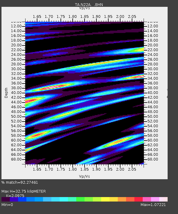
| Estimated Moho Depth: |
32.75 km |
| Estimated Crust Vp/Vs: |
2.10 |
| Assumed Crust Vp: |
6.159 km/s |
| Estimated Crust Vs: |
2.936 km/s |
| Estimated Crust Poisson's Ratio: |
0.35 |
|
| Radial Match: |
92.27461 % |
| Radial Bump: |
400 |
| Transverse Match: |
86.86943 % |
| Transverse Bump: |
400 |
| SOD ConfigId: |
2504 |
| Insert Time: |
2010-03-06 07:32:39.230 +0000 |
| GWidth: |
2.5 |
| Max Bumps: |
400 |
| Tol: |
0.001 |
|

Signal To Noise
| Channel | StoN | STA | LTA |
| TA:N22A: :BHN:20080705T02:21:05.698994Z | 48.6903 | 6.120138E-6 | 1.2569522E-7 |
| TA:N22A: :BHE:20080705T02:21:05.698994Z | 25.657274 | 2.6642313E-6 | 1.0383921E-7 |
| TA:N22A: :BHZ:20080705T02:21:05.698994Z | 21.63621 | 2.6648258E-6 | 1.231651E-7 |
| Arrivals |
| Ps | 6.0 SECOND |
| PpPs | 16 SECOND |
| PsPs/PpSs | 22 SECOND |


