You are here: Home > Network List > TA - USArray Transportable Network (new EarthScope stations) Stations List
> Station N22A Wattenberg Ranch, Walden, CO, USA > Earthquake Result Viewer
N22A Wattenberg Ranch, Walden, CO, USA - Earthquake Result Viewer
| Earthquake location: |
Santa Cruz Islands Region |
| Earthquake latitude/longitude: |
-11.0/164.5 |
| Earthquake time(UTC): |
2008/07/19 (201) 09:27:01 GMT |
| Earthquake Depth: |
11 km |
| Earthquake Magnitude: |
6.1 MB, 6.4 MS, 6.6 MW, 6.6 MW |
| Earthquake Catalog/Contributor: |
WHDF/NEIC |
|
| Network: |
TA USArray Transportable Network (new EarthScope stations) |
| Station: |
N22A Wattenberg Ranch, Walden, CO, USA |
| Lat/Lon: |
40.80 N/106.45 W |
| Elevation: |
2472 m |
|
| Distance: |
96.4 deg |
| Az: |
49.8 deg |
| Baz: |
261.026 deg |
| Ray Param: |
0.04052528 |
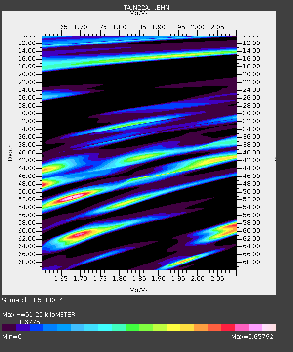
| Estimated Moho Depth: |
51.25 km |
| Estimated Crust Vp/Vs: |
1.68 |
| Assumed Crust Vp: |
6.159 km/s |
| Estimated Crust Vs: |
3.671 km/s |
| Estimated Crust Poisson's Ratio: |
0.22 |
|
| Radial Match: |
85.33014 % |
| Radial Bump: |
400 |
| Transverse Match: |
69.03974 % |
| Transverse Bump: |
400 |
| SOD ConfigId: |
2658 |
| Insert Time: |
2010-03-06 07:33:09.530 +0000 |
| GWidth: |
2.5 |
| Max Bumps: |
400 |
| Tol: |
0.001 |
|

Signal To Noise
| Channel | StoN | STA | LTA |
| TA:N22A: :BHN:20080719T09:39:58.624001Z | 10.497717 | 8.544658E-7 | 8.139539E-8 |
| TA:N22A: :BHE:20080719T09:39:58.624001Z | 0.730979 | 7.4423994E-8 | 1.0181412E-7 |
| TA:N22A: :BHZ:20080719T09:39:58.624001Z | 3.7785776 | 2.5621623E-7 | 6.780758E-8 |
| Arrivals |
| Ps | 5.7 SECOND |
| PpPs | 22 SECOND |
| PsPs/PpSs | 28 SECOND |


