You are here: Home > Network List > TA - USArray Transportable Network (new EarthScope stations) Stations List
> Station N22A Wattenberg Ranch, Walden, CO, USA > Earthquake Result Viewer
N22A Wattenberg Ranch, Walden, CO, USA - Earthquake Result Viewer
| Earthquake location: |
Off Coast Of Costa Rica |
| Earthquake latitude/longitude: |
7.9/-85.6 |
| Earthquake time(UTC): |
2009/08/13 (225) 09:37:35 GMT |
| Earthquake Depth: |
10 km |
| Earthquake Magnitude: |
5.8 MW, 5.3 MB |
| Earthquake Catalog/Contributor: |
WHDF/NEIC |
|
| Network: |
TA USArray Transportable Network (new EarthScope stations) |
| Station: |
N22A Wattenberg Ranch, Walden, CO, USA |
| Lat/Lon: |
40.80 N/106.45 W |
| Elevation: |
2472 m |
|
| Distance: |
37.6 deg |
| Az: |
333.755 deg |
| Baz: |
144.76 deg |
| Ray Param: |
0.07604526 |
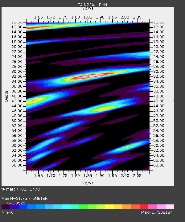
| Estimated Moho Depth: |
31.75 km |
| Estimated Crust Vp/Vs: |
1.85 |
| Assumed Crust Vp: |
6.159 km/s |
| Estimated Crust Vs: |
3.325 km/s |
| Estimated Crust Poisson's Ratio: |
0.29 |
|
| Radial Match: |
82.71478 % |
| Radial Bump: |
366 |
| Transverse Match: |
62.57321 % |
| Transverse Bump: |
400 |
| SOD ConfigId: |
2622 |
| Insert Time: |
2010-03-06 07:33:28.582 +0000 |
| GWidth: |
2.5 |
| Max Bumps: |
400 |
| Tol: |
0.001 |
|

Signal To Noise
| Channel | StoN | STA | LTA |
| TA:N22A: :BHN:20090813T09:44:19.248987Z | 6.029506 | 4.528163E-7 | 7.510006E-8 |
| TA:N22A: :BHE:20090813T09:44:19.248987Z | 1.8492696 | 2.3258261E-7 | 1.2576999E-7 |
| TA:N22A: :BHZ:20090813T09:44:19.248987Z | 1.8894634 | 2.6710052E-7 | 1.4136316E-7 |
| Arrivals |
| Ps | 4.7 SECOND |
| PpPs | 14 SECOND |
| PsPs/PpSs | 18 SECOND |


