You are here: Home > Network List > TA - USArray Transportable Network (new EarthScope stations) Stations List
> Station TPFO Pinon Flats, CA, USA > Earthquake Result Viewer
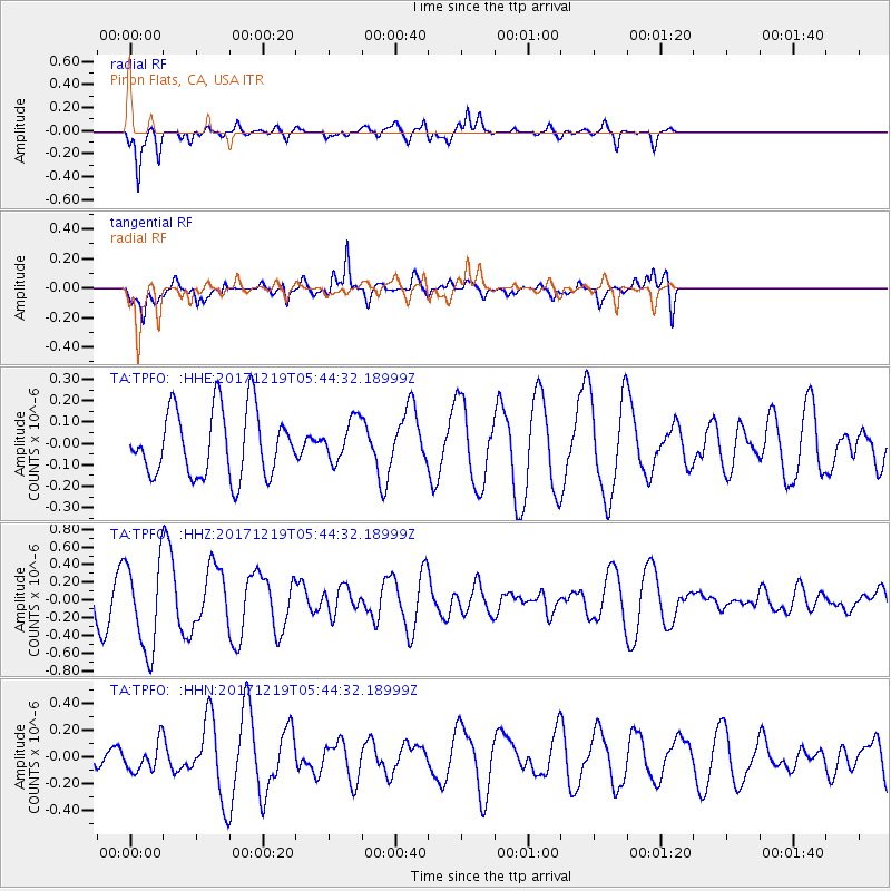
TPFO Pinon Flats, CA, USA - Earthquake Result Viewer
*The percent match for this event was below the threshold and hence no stack was calculated.
| Earthquake location: |
Southern East Pacific Rise |
| Earthquake latitude/longitude: |
-21.9/-114.2 |
| Earthquake time(UTC): |
2017/12/19 (353) 05:35:29 GMT |
| Earthquake Depth: |
10 km |
| Earthquake Magnitude: |
5.6 mb |
| Earthquake Catalog/Contributor: |
NEIC PDE/us |
|
| Network: |
TA USArray Transportable Network (new EarthScope stations) |
| Station: |
TPFO Pinon Flats, CA, USA |
| Lat/Lon: |
33.61 N/116.45 W |
| Elevation: |
1275 m |
|
| Distance: |
55.3 deg |
| Az: |
357.761 deg |
| Baz: |
177.508 deg |
| Ray Param: |
$rayparam |
*The percent match for this event was below the threshold and hence was not used in the summary stack. |
|
| Radial Match: |
68.32231 % |
| Radial Bump: |
348 |
| Transverse Match: |
61.261337 % |
| Transverse Bump: |
387 |
| SOD ConfigId: |
13570011 |
| Insert Time: |
2019-04-29 11:14:00.860 +0000 |
| GWidth: |
2.5 |
| Max Bumps: |
400 |
| Tol: |
0.001 |
|
Signal To Noise
| Channel | StoN | STA | LTA |
| TA:TPFO: :HHZ:20171219T05:44:32.18999Z | 1.9998015 | 5.0449904E-7 | 2.5227453E-7 |
| TA:TPFO: :HHN:20171219T05:44:32.18999Z | 0.80460036 | 1.0766895E-7 | 1.3381668E-7 |
| TA:TPFO: :HHE:20171219T05:44:32.18999Z | 0.6285515 | 9.706107E-8 | 1.5442023E-7 |
| Arrivals |
| Ps | |
| PpPs | |
| PsPs/PpSs | |


