You are here: Home > Network List > TA - USArray Transportable Network (new EarthScope stations) Stations List
> Station N22A Wattenberg Ranch, Walden, CO, USA > Earthquake Result Viewer
N22A Wattenberg Ranch, Walden, CO, USA - Earthquake Result Viewer
| Earthquake location: |
Near Coast Of Central Chile |
| Earthquake latitude/longitude: |
-32.5/-71.7 |
| Earthquake time(UTC): |
2008/12/18 (353) 21:19:28 GMT |
| Earthquake Depth: |
18 km |
| Earthquake Magnitude: |
5.8 MB, 6.0 MS, 6.2 MW, 6.1 MW |
| Earthquake Catalog/Contributor: |
WHDF/NEIC |
|
| Network: |
TA USArray Transportable Network (new EarthScope stations) |
| Station: |
N22A Wattenberg Ranch, Walden, CO, USA |
| Lat/Lon: |
40.80 N/106.45 W |
| Elevation: |
2472 m |
|
| Distance: |
79.6 deg |
| Az: |
333.92 deg |
| Baz: |
150.686 deg |
| Ray Param: |
0.048805684 |
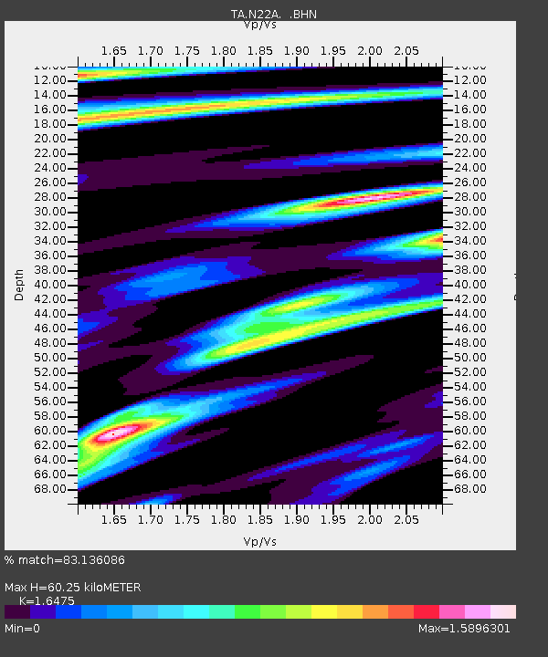
| Estimated Moho Depth: |
60.25 km |
| Estimated Crust Vp/Vs: |
1.65 |
| Assumed Crust Vp: |
6.159 km/s |
| Estimated Crust Vs: |
3.738 km/s |
| Estimated Crust Poisson's Ratio: |
0.21 |
|
| Radial Match: |
83.136086 % |
| Radial Bump: |
400 |
| Transverse Match: |
75.72342 % |
| Transverse Bump: |
400 |
| SOD ConfigId: |
2658 |
| Insert Time: |
2010-03-06 07:33:59.998 +0000 |
| GWidth: |
2.5 |
| Max Bumps: |
400 |
| Tol: |
0.001 |
|

Signal To Noise
| Channel | StoN | STA | LTA |
| TA:N22A: :BHN:20081218T21:31:03.223994Z | 4.5072355 | 4.5770986E-7 | 1.0155002E-7 |
| TA:N22A: :BHE:20081218T21:31:03.223994Z | 1.5801458 | 2.9697972E-7 | 1.879445E-7 |
| TA:N22A: :BHZ:20081218T21:31:03.223994Z | 1.053932 | 1.6944627E-7 | 1.6077534E-7 |
| Arrivals |
| Ps | 6.5 SECOND |
| PpPs | 25 SECOND |
| PsPs/PpSs | 32 SECOND |


