You are here: Home > Network List > UW - Pacific Northwest Regional Seismic Network Stations List
> Station YACT Amboy, WA, USA > Earthquake Result Viewer
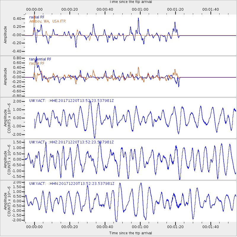
YACT Amboy, WA, USA - Earthquake Result Viewer
*The percent match for this event was below the threshold and hence no stack was calculated.
| Earthquake location: |
Southeast Of Shikoku, Japan |
| Earthquake latitude/longitude: |
30.6/132.1 |
| Earthquake time(UTC): |
2017/12/20 (354) 13:40:54 GMT |
| Earthquake Depth: |
10 km |
| Earthquake Magnitude: |
5.5 Mww |
| Earthquake Catalog/Contributor: |
NEIC PDE/us |
|
| Network: |
UW Pacific Northwest Regional Seismic Network |
| Station: |
YACT Amboy, WA, USA |
| Lat/Lon: |
45.93 N/122.42 W |
| Elevation: |
211 m |
|
| Distance: |
78.3 deg |
| Az: |
43.366 deg |
| Baz: |
301.993 deg |
| Ray Param: |
$rayparam |
*The percent match for this event was below the threshold and hence was not used in the summary stack. |
|
| Radial Match: |
62.754696 % |
| Radial Bump: |
323 |
| Transverse Match: |
66.61629 % |
| Transverse Bump: |
400 |
| SOD ConfigId: |
13570011 |
| Insert Time: |
2019-04-29 11:21:59.164 +0000 |
| GWidth: |
2.5 |
| Max Bumps: |
400 |
| Tol: |
0.001 |
|
Signal To Noise
| Channel | StoN | STA | LTA |
| UW:YACT: :HHZ:20171220T13:52:23.537981Z | 1.0345674 | 5.2747134E-7 | 5.0984727E-7 |
| UW:YACT: :HHN:20171220T13:52:23.537981Z | 1.071484 | 5.340985E-7 | 4.984662E-7 |
| UW:YACT: :HHE:20171220T13:52:23.537981Z | 2.514109 | 1.4527164E-6 | 5.778256E-7 |
| Arrivals |
| Ps | |
| PpPs | |
| PsPs/PpSs | |


