You are here: Home > Network List > TA - USArray Transportable Network (new EarthScope stations) Stations List
> Station A36M Sachs Harbour, NT, CAN > Earthquake Result Viewer
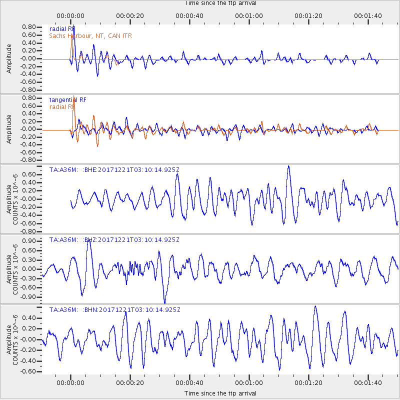
A36M Sachs Harbour, NT, CAN - Earthquake Result Viewer
*The percent match for this event was below the threshold and hence no stack was calculated.
| Earthquake location: |
Southeast Of Honshu, Japan |
| Earthquake latitude/longitude: |
29.3/142.7 |
| Earthquake time(UTC): |
2017/12/21 (355) 03:00:19 GMT |
| Earthquake Depth: |
16 km |
| Earthquake Magnitude: |
5.7 Mww |
| Earthquake Catalog/Contributor: |
NEIC PDE/us |
|
| Network: |
TA USArray Transportable Network (new EarthScope stations) |
| Station: |
A36M Sachs Harbour, NT, CAN |
| Lat/Lon: |
71.99 N/125.25 W |
| Elevation: |
32 m |
|
| Distance: |
63.1 deg |
| Az: |
20.41 deg |
| Baz: |
281.704 deg |
| Ray Param: |
$rayparam |
*The percent match for this event was below the threshold and hence was not used in the summary stack. |
|
| Radial Match: |
71.35323 % |
| Radial Bump: |
400 |
| Transverse Match: |
53.827354 % |
| Transverse Bump: |
400 |
| SOD ConfigId: |
13570011 |
| Insert Time: |
2019-04-29 11:27:51.217 +0000 |
| GWidth: |
2.5 |
| Max Bumps: |
400 |
| Tol: |
0.001 |
|
Signal To Noise
| Channel | StoN | STA | LTA |
| TA:A36M: :BHZ:20171221T03:10:14.925Z | 3.0634317 | 4.2525113E-7 | 1.3881528E-7 |
| TA:A36M: :BHN:20171221T03:10:14.925Z | 1.1673524 | 1.4563156E-7 | 1.2475373E-7 |
| TA:A36M: :BHE:20171221T03:10:14.925Z | 1.3469634 | 1.754577E-7 | 1.3026167E-7 |
| Arrivals |
| Ps | |
| PpPs | |
| PsPs/PpSs | |


