You are here: Home > Network List > TA - USArray Transportable Network (new EarthScope stations) Stations List
> Station K29M Barlow Dome, YT, CAN > Earthquake Result Viewer
K29M Barlow Dome, YT, CAN - Earthquake Result Viewer
| Earthquake location: |
Southeast Of Honshu, Japan |
| Earthquake latitude/longitude: |
29.3/142.7 |
| Earthquake time(UTC): |
2017/12/21 (355) 03:00:19 GMT |
| Earthquake Depth: |
16 km |
| Earthquake Magnitude: |
5.7 Mww |
| Earthquake Catalog/Contributor: |
NEIC PDE/us |
|
| Network: |
TA USArray Transportable Network (new EarthScope stations) |
| Station: |
K29M Barlow Dome, YT, CAN |
| Lat/Lon: |
63.84 N/137.52 W |
| Elevation: |
1367 m |
|
| Distance: |
59.7 deg |
| Az: |
30.355 deg |
| Baz: |
275.084 deg |
| Ray Param: |
0.062026117 |
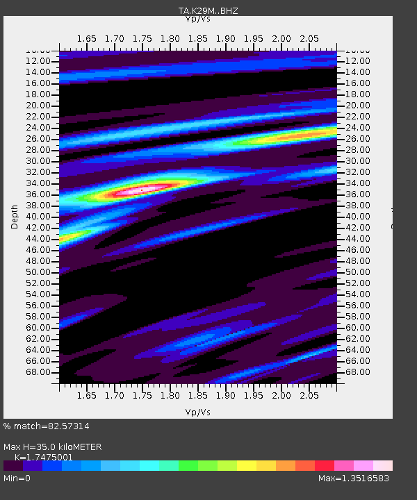
| Estimated Moho Depth: |
35.0 km |
| Estimated Crust Vp/Vs: |
1.75 |
| Assumed Crust Vp: |
6.566 km/s |
| Estimated Crust Vs: |
3.757 km/s |
| Estimated Crust Poisson's Ratio: |
0.26 |
|
| Radial Match: |
82.57314 % |
| Radial Bump: |
308 |
| Transverse Match: |
76.93507 % |
| Transverse Bump: |
324 |
| SOD ConfigId: |
13570011 |
| Insert Time: |
2019-04-29 11:28:15.574 +0000 |
| GWidth: |
2.5 |
| Max Bumps: |
400 |
| Tol: |
0.001 |
|
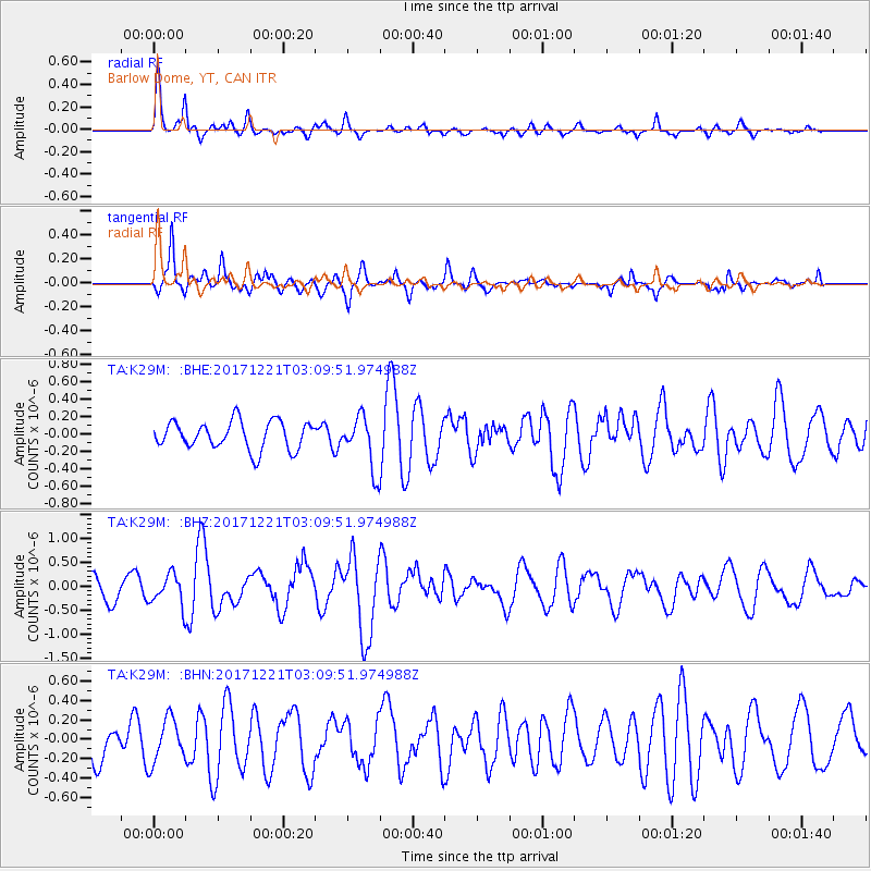
Signal To Noise
| Channel | StoN | STA | LTA |
| TA:K29M: :BHZ:20171221T03:09:51.974988Z | 1.6758524 | 3.3407827E-7 | 1.9934826E-7 |
| TA:K29M: :BHN:20171221T03:09:51.974988Z | 1.0925716 | 2.2547377E-7 | 2.0636978E-7 |
| TA:K29M: :BHE:20171221T03:09:51.974988Z | 1.4585716 | 2.3475629E-7 | 1.6094945E-7 |
| Arrivals |
| Ps | 4.2 SECOND |
| PpPs | 14 SECOND |
| PsPs/PpSs | 18 SECOND |


