You are here: Home > Network List > TA - USArray Transportable Network (new EarthScope stations) Stations List
> Station MDND Maddock, ND, USA > Earthquake Result Viewer
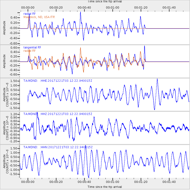
MDND Maddock, ND, USA - Earthquake Result Viewer
*The percent match for this event was below the threshold and hence no stack was calculated.
| Earthquake location: |
Southeast Of Honshu, Japan |
| Earthquake latitude/longitude: |
29.3/142.7 |
| Earthquake time(UTC): |
2017/12/21 (355) 03:00:19 GMT |
| Earthquake Depth: |
16 km |
| Earthquake Magnitude: |
5.7 Mww |
| Earthquake Catalog/Contributor: |
NEIC PDE/us |
|
| Network: |
TA USArray Transportable Network (new EarthScope stations) |
| Station: |
MDND Maddock, ND, USA |
| Lat/Lon: |
47.85 N/99.60 W |
| Elevation: |
479 m |
|
| Distance: |
85.0 deg |
| Az: |
36.78 deg |
| Baz: |
309.055 deg |
| Ray Param: |
$rayparam |
*The percent match for this event was below the threshold and hence was not used in the summary stack. |
|
| Radial Match: |
77.32663 % |
| Radial Bump: |
346 |
| Transverse Match: |
56.629738 % |
| Transverse Bump: |
400 |
| SOD ConfigId: |
13570011 |
| Insert Time: |
2019-04-29 11:28:21.334 +0000 |
| GWidth: |
2.5 |
| Max Bumps: |
400 |
| Tol: |
0.001 |
|
Signal To Noise
| Channel | StoN | STA | LTA |
| TA:MDND: :HHZ:20171221T03:12:22.940015Z | 1.8861581 | 3.5347514E-7 | 1.8740484E-7 |
| TA:MDND: :HHN:20171221T03:12:22.940015Z | 1.0984527 | 6.1344247E-7 | 5.584605E-7 |
| TA:MDND: :HHE:20171221T03:12:22.940015Z | 1.2894771 | 4.89309E-7 | 3.7946313E-7 |
| Arrivals |
| Ps | |
| PpPs | |
| PsPs/PpSs | |


