You are here: Home > Network List > TJ - Tajikistan National Seismic Network Stations List
> Station GEZN Gezan, Tajikistan > Earthquake Result Viewer
GEZN Gezan, Tajikistan - Earthquake Result Viewer

| Earthquake location: |
Southeast Of Honshu, Japan |
| Earthquake latitude/longitude: |
29.3/142.7 |
| Earthquake time(UTC): |
2017/12/21 (355) 03:00:19 GMT |
| Earthquake Depth: |
16 km |
| Earthquake Magnitude: |
5.7 Mww |
| Earthquake Catalog/Contributor: |
NEIC PDE/us |
|
| Network: |
TJ Tajikistan National Seismic Network |
| Station: |
GEZN Gezan, Tajikistan |
| Lat/Lon: |
39.28 N/67.72 E |
| Elevation: |
1485 m |
|
| Distance: |
61.2 deg |
| Az: |
301.152 deg |
| Baz: |
74.427 deg |
| Ray Param: |
0.061038844 |
| Estimated Moho Depth: |
47.75 km |
| Estimated Crust Vp/Vs: |
1.79 |
| Assumed Crust Vp: |
6.444 km/s |
| Estimated Crust Vs: |
3.605 km/s |
| Estimated Crust Poisson's Ratio: |
0.27 |
|
| Radial Match: |
86.71929 % |
| Radial Bump: |
400 |
| Transverse Match: |
75.37908 % |
| Transverse Bump: |
400 |
| SOD ConfigId: |
13570011 |
| Insert Time: |
2019-04-29 11:28:37.010 +0000 |
| GWidth: |
2.5 |
| Max Bumps: |
400 |
| Tol: |
0.001 |
|
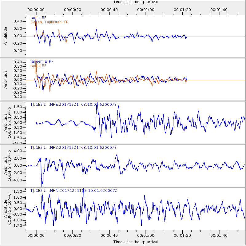
Signal To Noise
| Channel | StoN | STA | LTA |
| TJ:GEZN: :HHZ:20171221T03:10:01.620007Z | 21.129576 | 2.138283E-6 | 1.0119858E-7 |
| TJ:GEZN: :HHN:20171221T03:10:01.620007Z | 3.1271877 | 5.106806E-7 | 1.6330345E-7 |
| TJ:GEZN: :HHE:20171221T03:10:01.620007Z | 5.553346 | 7.893396E-7 | 1.4213767E-7 |
| Arrivals |
| Ps | 6.1 SECOND |
| PpPs | 20 SECOND |
| PsPs/PpSs | 26 SECOND |


