You are here: Home > Network List > TJ - Tajikistan National Seismic Network Stations List
> Station CHRDR Chorukh Dayron, Tajikistan > Earthquake Result Viewer
CHRDR Chorukh Dayron, Tajikistan - Earthquake Result Viewer
| Earthquake location: |
Southeast Of Honshu, Japan |
| Earthquake latitude/longitude: |
29.3/142.7 |
| Earthquake time(UTC): |
2017/12/21 (355) 03:00:19 GMT |
| Earthquake Depth: |
16 km |
| Earthquake Magnitude: |
5.7 Mww |
| Earthquake Catalog/Contributor: |
NEIC PDE/us |
|
| Network: |
TJ Tajikistan National Seismic Network |
| Station: |
CHRDR Chorukh Dayron, Tajikistan |
| Lat/Lon: |
40.39 N/69.67 E |
| Elevation: |
580 m |
|
| Distance: |
59.4 deg |
| Az: |
301.937 deg |
| Baz: |
76.064 deg |
| Ray Param: |
0.062181715 |
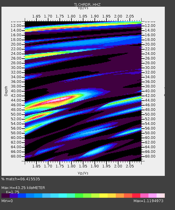
| Estimated Moho Depth: |
43.25 km |
| Estimated Crust Vp/Vs: |
1.75 |
| Assumed Crust Vp: |
6.316 km/s |
| Estimated Crust Vs: |
3.609 km/s |
| Estimated Crust Poisson's Ratio: |
0.26 |
|
| Radial Match: |
86.415535 % |
| Radial Bump: |
400 |
| Transverse Match: |
77.63473 % |
| Transverse Bump: |
357 |
| SOD ConfigId: |
13570011 |
| Insert Time: |
2019-04-29 11:28:38.424 +0000 |
| GWidth: |
2.5 |
| Max Bumps: |
400 |
| Tol: |
0.001 |
|

Signal To Noise
| Channel | StoN | STA | LTA |
| TJ:CHRDR: :HHZ:20171221T03:09:49.750012Z | 15.530848 | 2.1187238E-6 | 1.3642035E-7 |
| TJ:CHRDR: :HHN:20171221T03:09:49.750012Z | 2.2329488 | 2.3594181E-7 | 1.0566378E-7 |
| TJ:CHRDR: :HHE:20171221T03:09:49.750012Z | 4.8106427 | 8.460046E-7 | 1.7586103E-7 |
| Arrivals |
| Ps | 5.4 SECOND |
| PpPs | 18 SECOND |
| PsPs/PpSs | 23 SECOND |


