You are here: Home > Network List > CI - Caltech Regional Seismic Network Stations List
> Station SMM Simmler, CA, USA > Earthquake Result Viewer
SMM Simmler, CA, USA - Earthquake Result Viewer
*The percent match for this event was below the threshold and hence no stack was calculated.
| Earthquake location: |
Northern Yukon Territory, Canada |
| Earthquake latitude/longitude: |
65.5/-134.1 |
| Earthquake time(UTC): |
2017/12/22 (356) 08:00:13 GMT |
| Earthquake Depth: |
3.5 km |
| Earthquake Magnitude: |
5.0 Mww |
| Earthquake Catalog/Contributor: |
NEIC PDE/us |
|
| Network: |
CI Caltech Regional Seismic Network |
| Station: |
SMM Simmler, CA, USA |
| Lat/Lon: |
35.31 N/120.00 W |
| Elevation: |
599 m |
|
| Distance: |
31.4 deg |
| Az: |
157.506 deg |
| Baz: |
348.742 deg |
| Ray Param: |
$rayparam |
*The percent match for this event was below the threshold and hence was not used in the summary stack. |
|
| Radial Match: |
80.712494 % |
| Radial Bump: |
400 |
| Transverse Match: |
77.76313 % |
| Transverse Bump: |
400 |
| SOD ConfigId: |
13570011 |
| Insert Time: |
2019-04-29 11:31:09.402 +0000 |
| GWidth: |
2.5 |
| Max Bumps: |
400 |
| Tol: |
0.001 |
|
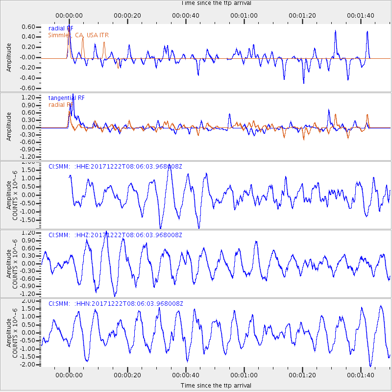
Signal To Noise
| Channel | StoN | STA | LTA |
| CI:SMM: :HHZ:20171222T08:06:03.968008Z | 1.3131835 | 4.1329992E-7 | 3.1473127E-7 |
| CI:SMM: :HHN:20171222T08:06:03.968008Z | 1.8237709 | 7.866516E-7 | 4.3133247E-7 |
| CI:SMM: :HHE:20171222T08:06:03.968008Z | 2.3062773 | 1.1939693E-6 | 5.177041E-7 |
| Arrivals |
| Ps | |
| PpPs | |
| PsPs/PpSs | |


