You are here: Home > Network List > CN - Canadian National Seismograph Network Stations List
> Station INK INUVIK, NT > Earthquake Result Viewer
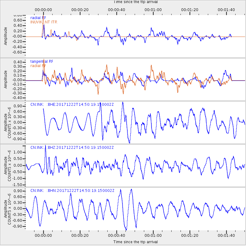
INK INUVIK, NT - Earthquake Result Viewer
*The percent match for this event was below the threshold and hence no stack was calculated.
| Earthquake location: |
Near East Coast Of Kamchatka |
| Earthquake latitude/longitude: |
53.8/160.5 |
| Earthquake time(UTC): |
2017/12/22 (356) 14:44:17 GMT |
| Earthquake Depth: |
46 km |
| Earthquake Magnitude: |
5.4 Mww |
| Earthquake Catalog/Contributor: |
NEIC PDE/us |
|
| Network: |
CN Canadian National Seismograph Network |
| Station: |
INK INUVIK, NT |
| Lat/Lon: |
68.31 N/133.53 W |
| Elevation: |
44 m |
|
| Distance: |
33.1 deg |
| Az: |
38.414 deg |
| Baz: |
277.909 deg |
| Ray Param: |
$rayparam |
*The percent match for this event was below the threshold and hence was not used in the summary stack. |
|
| Radial Match: |
56.71884 % |
| Radial Bump: |
400 |
| Transverse Match: |
38.327908 % |
| Transverse Bump: |
400 |
| SOD ConfigId: |
13570011 |
| Insert Time: |
2019-04-29 11:38:21.231 +0000 |
| GWidth: |
2.5 |
| Max Bumps: |
400 |
| Tol: |
0.001 |
|
Signal To Noise
| Channel | StoN | STA | LTA |
| CN:INK: :BHZ:20171222T14:50:19.150002Z | 2.5519476 | 5.9458E-7 | 2.3299066E-7 |
| CN:INK: :BHN:20171222T14:50:19.150002Z | 1.2037845 | 2.3755705E-7 | 1.9734183E-7 |
| CN:INK: :BHE:20171222T14:50:19.150002Z | 1.738097 | 5.9551013E-7 | 3.4262195E-7 |
| Arrivals |
| Ps | |
| PpPs | |
| PsPs/PpSs | |


