You are here: Home > Network List > US - United States National Seismic Network Stations List
> Station GLMI Grayling, Michigan, USA > Earthquake Result Viewer
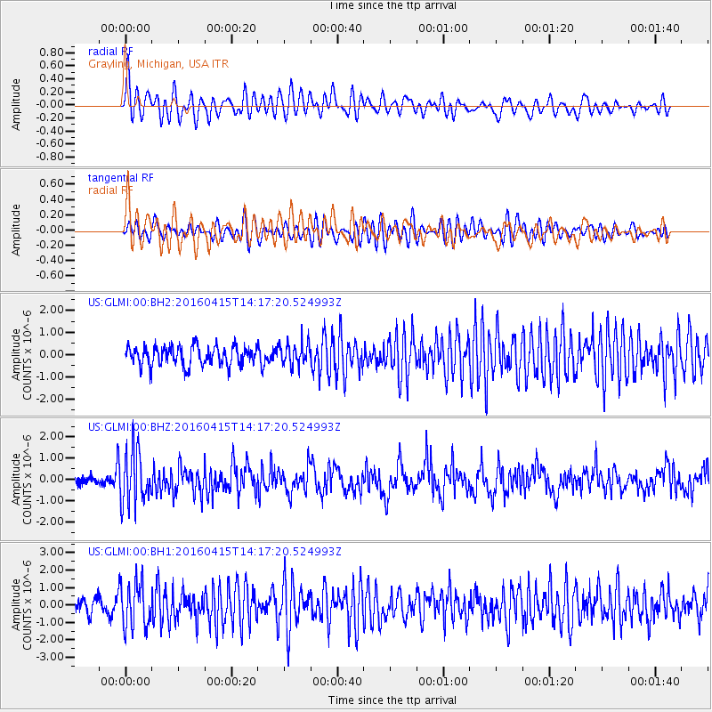
GLMI Grayling, Michigan, USA - Earthquake Result Viewer
*The percent match for this event was below the threshold and hence no stack was calculated.
| Earthquake location: |
Off Coast Of Chiapas, Mexico |
| Earthquake latitude/longitude: |
13.5/-92.2 |
| Earthquake time(UTC): |
2016/04/15 (106) 14:11:29 GMT |
| Earthquake Depth: |
48 km |
| Earthquake Magnitude: |
6.2 MWP |
| Earthquake Catalog/Contributor: |
NEIC PDE/NEIC COMCAT |
|
| Network: |
US United States National Seismic Network |
| Station: |
GLMI Grayling, Michigan, USA |
| Lat/Lon: |
44.82 N/84.62 W |
| Elevation: |
387 m |
|
| Distance: |
31.9 deg |
| Az: |
10.185 deg |
| Baz: |
193.989 deg |
| Ray Param: |
$rayparam |
*The percent match for this event was below the threshold and hence was not used in the summary stack. |
|
| Radial Match: |
68.87602 % |
| Radial Bump: |
400 |
| Transverse Match: |
54.82832 % |
| Transverse Bump: |
400 |
| SOD ConfigId: |
1475611 |
| Insert Time: |
2016-04-29 14:24:57.267 +0000 |
| GWidth: |
2.5 |
| Max Bumps: |
400 |
| Tol: |
0.001 |
|
Signal To Noise
| Channel | StoN | STA | LTA |
| US:GLMI:00:BHZ:20160415T14:17:20.524993Z | 5.3331347 | 1.2612943E-6 | 2.3650149E-7 |
| US:GLMI:00:BH1:20160415T14:17:20.524993Z | 3.0670567 | 1.2860141E-6 | 4.192991E-7 |
| US:GLMI:00:BH2:20160415T14:17:20.524993Z | 1.1629416 | 5.063088E-7 | 4.3536906E-7 |
| Arrivals |
| Ps | |
| PpPs | |
| PsPs/PpSs | |


