You are here: Home > Network List > TA - USArray Transportable Network (new EarthScope stations) Stations List
> Station R17K Ugashik Creek, AK, USA > Earthquake Result Viewer
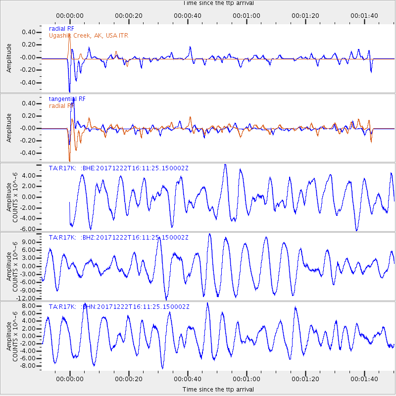
R17K Ugashik Creek, AK, USA - Earthquake Result Viewer
*The percent match for this event was below the threshold and hence no stack was calculated.
| Earthquake location: |
Andaman Islands, India Region |
| Earthquake latitude/longitude: |
10.0/93.0 |
| Earthquake time(UTC): |
2017/12/22 (356) 15:58:49 GMT |
| Earthquake Depth: |
34 km |
| Earthquake Magnitude: |
4.8 Mww |
| Earthquake Catalog/Contributor: |
NEIC PDE/us |
|
| Network: |
TA USArray Transportable Network (new EarthScope stations) |
| Station: |
R17K Ugashik Creek, AK, USA |
| Lat/Lon: |
57.64 N/156.39 W |
| Elevation: |
273 m |
|
| Distance: |
92.3 deg |
| Az: |
30.255 deg |
| Baz: |
292.676 deg |
| Ray Param: |
$rayparam |
*The percent match for this event was below the threshold and hence was not used in the summary stack. |
|
| Radial Match: |
42.39122 % |
| Radial Bump: |
400 |
| Transverse Match: |
69.83468 % |
| Transverse Bump: |
400 |
| SOD ConfigId: |
13570011 |
| Insert Time: |
2019-04-29 11:48:24.157 +0000 |
| GWidth: |
2.5 |
| Max Bumps: |
400 |
| Tol: |
0.001 |
|
Signal To Noise
| Channel | StoN | STA | LTA |
| TA:R17K: :BHZ:20171222T16:11:25.150002Z | 0.83471805 | 2.0370815E-6 | 2.4404428E-6 |
| TA:R17K: :BHN:20171222T16:11:25.150002Z | 1.7808143 | 4.3119003E-6 | 2.4213082E-6 |
| TA:R17K: :BHE:20171222T16:11:25.150002Z | 0.8053674 | 2.2350412E-6 | 2.7751823E-6 |
| Arrivals |
| Ps | |
| PpPs | |
| PsPs/PpSs | |


