You are here: Home > Network List > TA - USArray Transportable Network (new EarthScope stations) Stations List
> Station 109C Camp Elliot, Mirimar, CA, USA > Earthquake Result Viewer
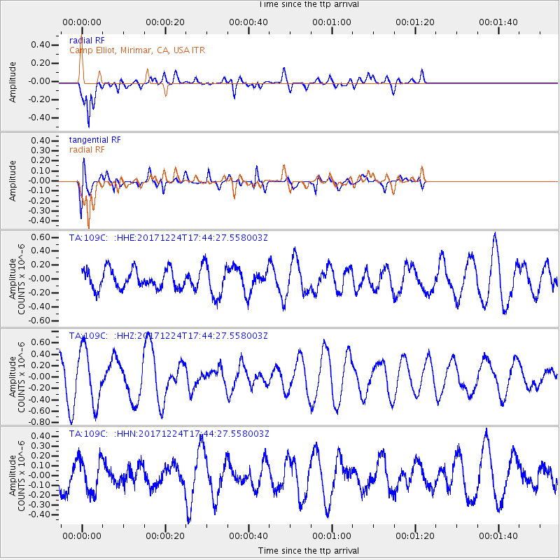
109C Camp Elliot, Mirimar, CA, USA - Earthquake Result Viewer
*The percent match for this event was below the threshold and hence no stack was calculated.
| Earthquake location: |
Samoa Islands Region |
| Earthquake latitude/longitude: |
-15.3/-172.9 |
| Earthquake time(UTC): |
2017/12/24 (358) 17:33:36 GMT |
| Earthquake Depth: |
10 km |
| Earthquake Magnitude: |
5.5 Mwb |
| Earthquake Catalog/Contributor: |
NEIC PDE/us |
|
| Network: |
TA USArray Transportable Network (new EarthScope stations) |
| Station: |
109C Camp Elliot, Mirimar, CA, USA |
| Lat/Lon: |
32.89 N/117.11 W |
| Elevation: |
150 m |
|
| Distance: |
71.7 deg |
| Az: |
47.153 deg |
| Baz: |
237.214 deg |
| Ray Param: |
$rayparam |
*The percent match for this event was below the threshold and hence was not used in the summary stack. |
|
| Radial Match: |
65.04097 % |
| Radial Bump: |
400 |
| Transverse Match: |
55.35344 % |
| Transverse Bump: |
400 |
| SOD ConfigId: |
13570011 |
| Insert Time: |
2019-04-29 11:53:54.264 +0000 |
| GWidth: |
2.5 |
| Max Bumps: |
400 |
| Tol: |
0.001 |
|
Signal To Noise
| Channel | StoN | STA | LTA |
| TA:109C: :HHZ:20171224T17:44:27.558003Z | 2.937017 | 4.819394E-7 | 1.6409146E-7 |
| TA:109C: :HHN:20171224T17:44:27.558003Z | 1.2189528 | 1.7198101E-7 | 1.4108916E-7 |
| TA:109C: :HHE:20171224T17:44:27.558003Z | 1.7986636 | 2.409163E-7 | 1.3394182E-7 |
| Arrivals |
| Ps | |
| PpPs | |
| PsPs/PpSs | |


