You are here: Home > Network List > TA - USArray Transportable Network (new EarthScope stations) Stations List
> Station E20K Nigu River, AK, USA > Earthquake Result Viewer
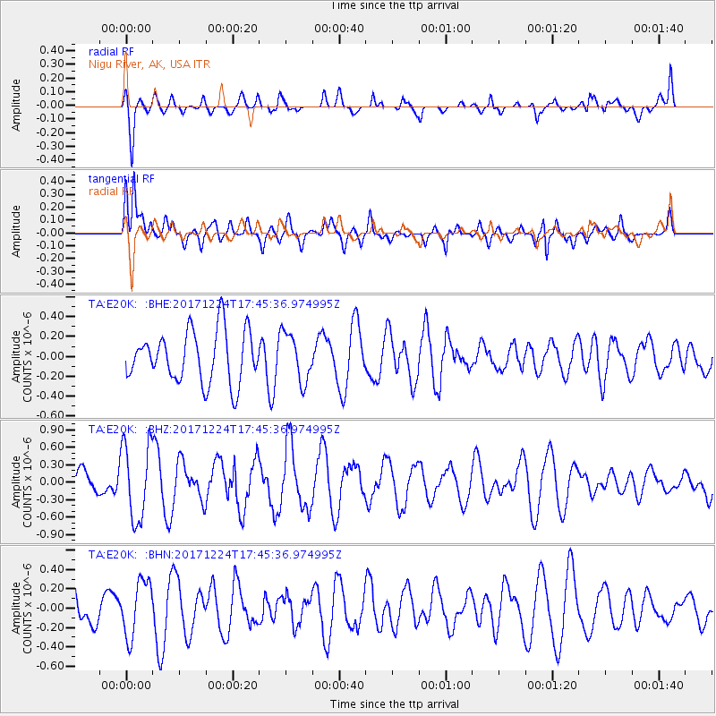
E20K Nigu River, AK, USA - Earthquake Result Viewer
*The percent match for this event was below the threshold and hence no stack was calculated.
| Earthquake location: |
Samoa Islands Region |
| Earthquake latitude/longitude: |
-15.3/-172.9 |
| Earthquake time(UTC): |
2017/12/24 (358) 17:33:36 GMT |
| Earthquake Depth: |
10 km |
| Earthquake Magnitude: |
5.5 Mwb |
| Earthquake Catalog/Contributor: |
NEIC PDE/us |
|
| Network: |
TA USArray Transportable Network (new EarthScope stations) |
| Station: |
E20K Nigu River, AK, USA |
| Lat/Lon: |
68.26 N/156.19 W |
| Elevation: |
866 m |
|
| Distance: |
84.3 deg |
| Az: |
6.194 deg |
| Baz: |
196.225 deg |
| Ray Param: |
$rayparam |
*The percent match for this event was below the threshold and hence was not used in the summary stack. |
|
| Radial Match: |
60.890545 % |
| Radial Bump: |
400 |
| Transverse Match: |
66.36984 % |
| Transverse Bump: |
400 |
| SOD ConfigId: |
13570011 |
| Insert Time: |
2019-04-29 11:54:01.253 +0000 |
| GWidth: |
2.5 |
| Max Bumps: |
400 |
| Tol: |
0.001 |
|
Signal To Noise
| Channel | StoN | STA | LTA |
| TA:E20K: :BHZ:20171224T17:45:36.974995Z | 3.4892387 | 6.5890237E-7 | 1.8883843E-7 |
| TA:E20K: :BHN:20171224T17:45:36.974995Z | 2.550519 | 2.92087E-7 | 1.1452061E-7 |
| TA:E20K: :BHE:20171224T17:45:36.974995Z | 0.94078285 | 2.4371766E-7 | 2.5905837E-7 |
| Arrivals |
| Ps | |
| PpPs | |
| PsPs/PpSs | |


