You are here: Home > Network List > TA - USArray Transportable Network (new EarthScope stations) Stations List
> Station 428A Kincaid Ranch, Fort Stockton, TX, USA > Earthquake Result Viewer
428A Kincaid Ranch, Fort Stockton, TX, USA - Earthquake Result Viewer
| Earthquake location: |
Andreanof Islands, Aleutian Is. |
| Earthquake latitude/longitude: |
52.2/-178.7 |
| Earthquake time(UTC): |
2008/03/22 (082) 21:24:11 GMT |
| Earthquake Depth: |
132 km |
| Earthquake Magnitude: |
5.8 MB, 6.2 MW, 6.1 MW |
| Earthquake Catalog/Contributor: |
WHDF/NEIC |
|
| Network: |
TA USArray Transportable Network (new EarthScope stations) |
| Station: |
428A Kincaid Ranch, Fort Stockton, TX, USA |
| Lat/Lon: |
30.73 N/102.68 W |
| Elevation: |
982 m |
|
| Distance: |
58.1 deg |
| Az: |
79.87 deg |
| Baz: |
315.253 deg |
| Ray Param: |
0.06266563 |
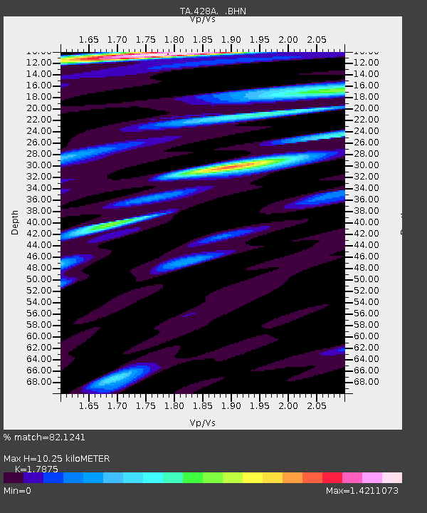
| Estimated Moho Depth: |
10.25 km |
| Estimated Crust Vp/Vs: |
1.79 |
| Assumed Crust Vp: |
6.121 km/s |
| Estimated Crust Vs: |
3.424 km/s |
| Estimated Crust Poisson's Ratio: |
0.27 |
|
| Radial Match: |
82.1241 % |
| Radial Bump: |
400 |
| Transverse Match: |
76.85343 % |
| Transverse Bump: |
400 |
| SOD ConfigId: |
2564 |
| Insert Time: |
2010-03-06 07:37:49.397 +0000 |
| GWidth: |
2.5 |
| Max Bumps: |
400 |
| Tol: |
0.001 |
|
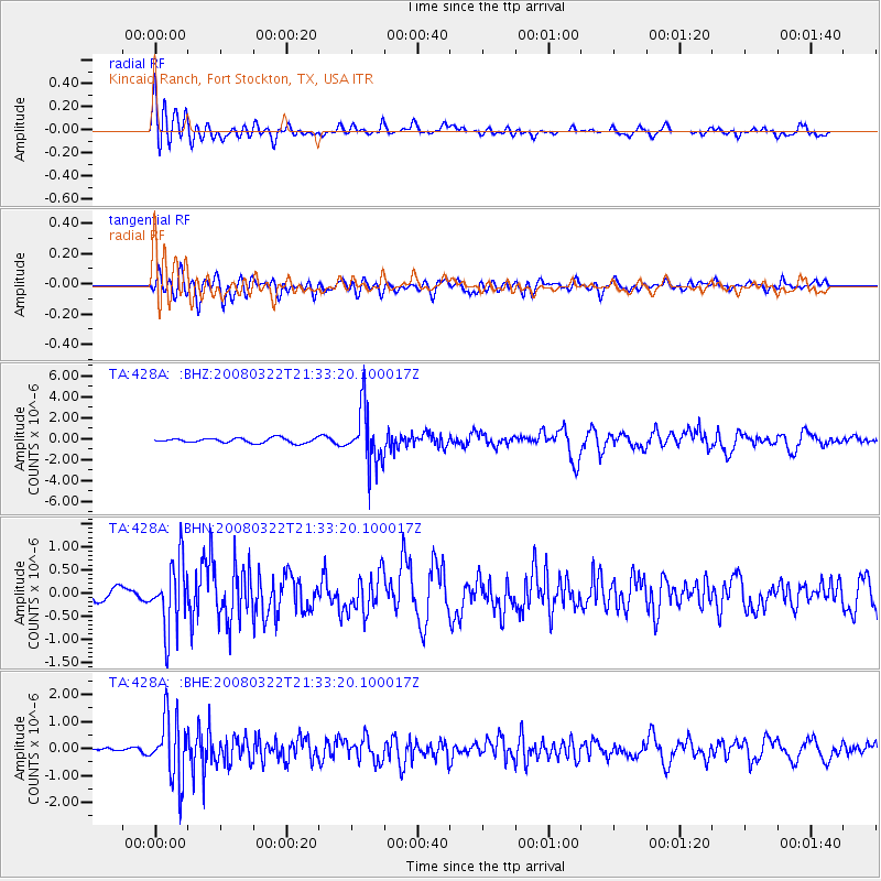
Signal To Noise
| Channel | StoN | STA | LTA |
| TA:428A: :BHN:20080322T21:33:20.100017Z | 4.1552563 | 7.2985955E-7 | 1.7564729E-7 |
| TA:428A: :BHE:20080322T21:33:20.100017Z | 11.707346 | 1.1685449E-6 | 9.9812965E-8 |
| TA:428A: :BHZ:20080322T21:33:20.100017Z | 11.698686 | 2.660437E-6 | 2.2741332E-7 |
| Arrivals |
| Ps | 1.4 SECOND |
| PpPs | 4.5 SECOND |
| PsPs/PpSs | 5.8 SECOND |


