You are here: Home > Network List > TA - USArray Transportable Network (new EarthScope stations) Stations List
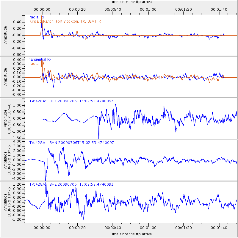
> Station 428A Kincaid Ranch, Fort Stockton, TX, USA > Earthquake Result Viewer
428A Kincaid Ranch, Fort Stockton, TX, USA - Earthquake Result Viewer
| Earthquake location: |
Rat Islands, Aleutian Islands |
| Earthquake latitude/longitude: |
50.4/177.0 |
| Earthquake time(UTC): |
2009/07/06 (187) 14:53:12 GMT |
| Earthquake Depth: |
22 km |
| Earthquake Magnitude: |
6.0 MB, 5.8 MS, 6.1 MW, 6.0 MW |
| Earthquake Catalog/Contributor: |
WHDF/NEIC |
|
| Network: |
TA USArray Transportable Network (new EarthScope stations) |
| Station: |
428A Kincaid Ranch, Fort Stockton, TX, USA |
| Lat/Lon: |
30.73 N/102.68 W |
| Elevation: |
982 m |
|
| Distance: |
61.1 deg |
| Az: |
75.861 deg |
| Baz: |
313.935 deg |
| Ray Param: |
0.061072934 |
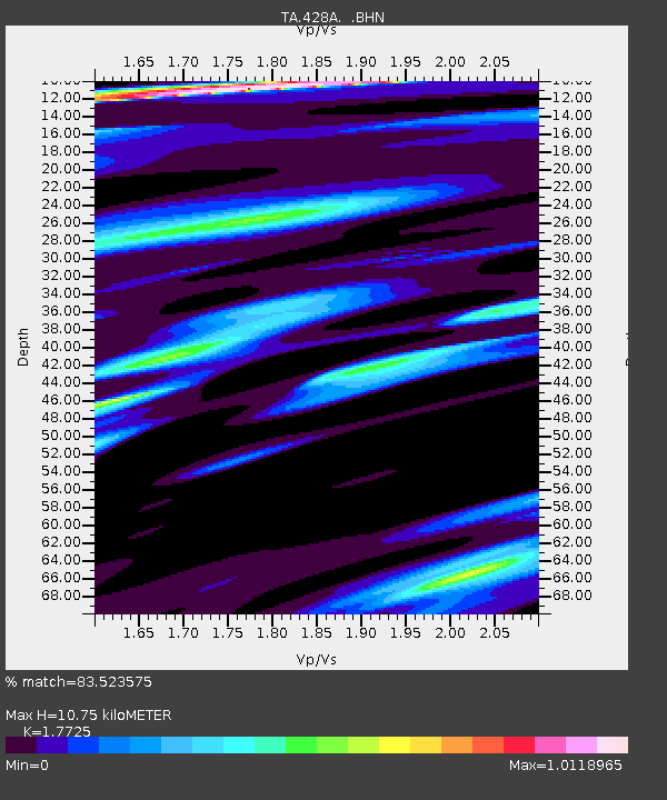
| Estimated Moho Depth: |
10.75 km |
| Estimated Crust Vp/Vs: |
1.77 |
| Assumed Crust Vp: |
6.121 km/s |
| Estimated Crust Vs: |
3.453 km/s |
| Estimated Crust Poisson's Ratio: |
0.27 |
|
| Radial Match: |
83.523575 % |
| Radial Bump: |
400 |
| Transverse Match: |
80.06037 % |
| Transverse Bump: |
400 |
| SOD ConfigId: |
2622 |
| Insert Time: |
2010-03-06 07:37:54.302 +0000 |
| GWidth: |
2.5 |
| Max Bumps: |
400 |
| Tol: |
0.001 |
|
Signal To Noise
| Channel | StoN | STA | LTA |
| TA:428A: :BHN:20090706T15:02:53.474009Z | 8.263726 | 1.8195124E-6 | 2.2018061E-7 |
| TA:428A: :BHE:20090706T15:02:53.474009Z | 2.8295536 | 4.7803877E-7 | 1.6894495E-7 |
| TA:428A: :BHZ:20090706T15:02:53.474009Z | 2.4018838 | 4.650422E-7 | 1.936156E-7 |
| Arrivals |
| Ps | 1.4 SECOND |
| PpPs | 4.7 SECOND |
| PsPs/PpSs | 6.1 SECOND |


