You are here: Home > Network List > TA - USArray Transportable Network (new EarthScope stations) Stations List
> Station 428A Kincaid Ranch, Fort Stockton, TX, USA > Earthquake Result Viewer
428A Kincaid Ranch, Fort Stockton, TX, USA - Earthquake Result Viewer
| Earthquake location: |
Tonga Islands |
| Earthquake latitude/longitude: |
-20.8/-174.3 |
| Earthquake time(UTC): |
2009/07/30 (211) 20:05:34 GMT |
| Earthquake Depth: |
10 km |
| Earthquake Magnitude: |
5.9 MB, 5.7 MS, 5.8 MW, 5.7 MW |
| Earthquake Catalog/Contributor: |
WHDF/NEIC |
|
| Network: |
TA USArray Transportable Network (new EarthScope stations) |
| Station: |
428A Kincaid Ranch, Fort Stockton, TX, USA |
| Lat/Lon: |
30.73 N/102.68 W |
| Elevation: |
982 m |
|
| Distance: |
85.7 deg |
| Az: |
55.009 deg |
| Baz: |
242.852 deg |
| Ray Param: |
0.044568103 |
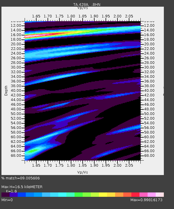
| Estimated Moho Depth: |
16.5 km |
| Estimated Crust Vp/Vs: |
1.60 |
| Assumed Crust Vp: |
6.121 km/s |
| Estimated Crust Vs: |
3.825 km/s |
| Estimated Crust Poisson's Ratio: |
0.18 |
|
| Radial Match: |
89.085686 % |
| Radial Bump: |
400 |
| Transverse Match: |
75.04492 % |
| Transverse Bump: |
394 |
| SOD ConfigId: |
2622 |
| Insert Time: |
2010-03-06 07:37:56.171 +0000 |
| GWidth: |
2.5 |
| Max Bumps: |
400 |
| Tol: |
0.001 |
|
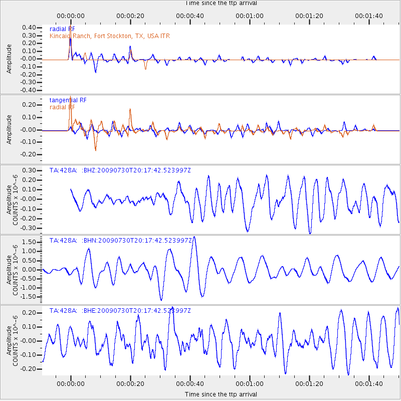
Signal To Noise
| Channel | StoN | STA | LTA |
| TA:428A: :BHN:20090730T20:17:42.523997Z | 3.6979568 | 3.2615927E-7 | 8.819986E-8 |
| TA:428A: :BHE:20090730T20:17:42.523997Z | 0.679686 | 5.0702152E-8 | 7.459643E-8 |
| TA:428A: :BHZ:20090730T20:17:42.523997Z | 1.6090218 | 7.446904E-8 | 4.628218E-8 |
| Arrivals |
| Ps | 1.7 SECOND |
| PpPs | 6.8 SECOND |
| PsPs/PpSs | 8.5 SECOND |


