You are here: Home > Network List > CI - Caltech Regional Seismic Network Stations List
> Station MPP McPhearson Peak > Earthquake Result Viewer
MPP McPhearson Peak - Earthquake Result Viewer
*The percent match for this event was below the threshold and hence no stack was calculated.
| Earthquake location: |
South Of Mariana Islands |
| Earthquake latitude/longitude: |
12.0/144.4 |
| Earthquake time(UTC): |
2017/12/27 (361) 23:58:02 GMT |
| Earthquake Depth: |
15 km |
| Earthquake Magnitude: |
5.5 mb |
| Earthquake Catalog/Contributor: |
NEIC PDE/us |
|
| Network: |
CI Caltech Regional Seismic Network |
| Station: |
MPP McPhearson Peak |
| Lat/Lon: |
34.89 N/119.81 W |
| Elevation: |
1739 m |
|
| Distance: |
87.9 deg |
| Az: |
54.924 deg |
| Baz: |
283.105 deg |
| Ray Param: |
$rayparam |
*The percent match for this event was below the threshold and hence was not used in the summary stack. |
|
| Radial Match: |
36.166794 % |
| Radial Bump: |
400 |
| Transverse Match: |
35.843777 % |
| Transverse Bump: |
400 |
| SOD ConfigId: |
13570011 |
| Insert Time: |
2019-04-29 11:57:50.110 +0000 |
| GWidth: |
2.5 |
| Max Bumps: |
400 |
| Tol: |
0.001 |
|
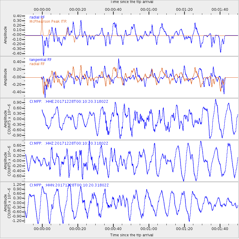
Signal To Noise
| Channel | StoN | STA | LTA |
| CI:MPP: :HHZ:20171228T00:10:20.31802Z | 0.6813379 | 1.5213696E-7 | 2.2329151E-7 |
| CI:MPP: :HHN:20171228T00:10:20.31802Z | 2.5104163 | 8.1613825E-7 | 3.2510076E-7 |
| CI:MPP: :HHE:20171228T00:10:20.31802Z | 1.6281031 | 5.243698E-7 | 3.2207404E-7 |
| Arrivals |
| Ps | |
| PpPs | |
| PsPs/PpSs | |


