You are here: Home > Network List > TA - USArray Transportable Network (new EarthScope stations) Stations List
> Station 428A Kincaid Ranch, Fort Stockton, TX, USA > Earthquake Result Viewer
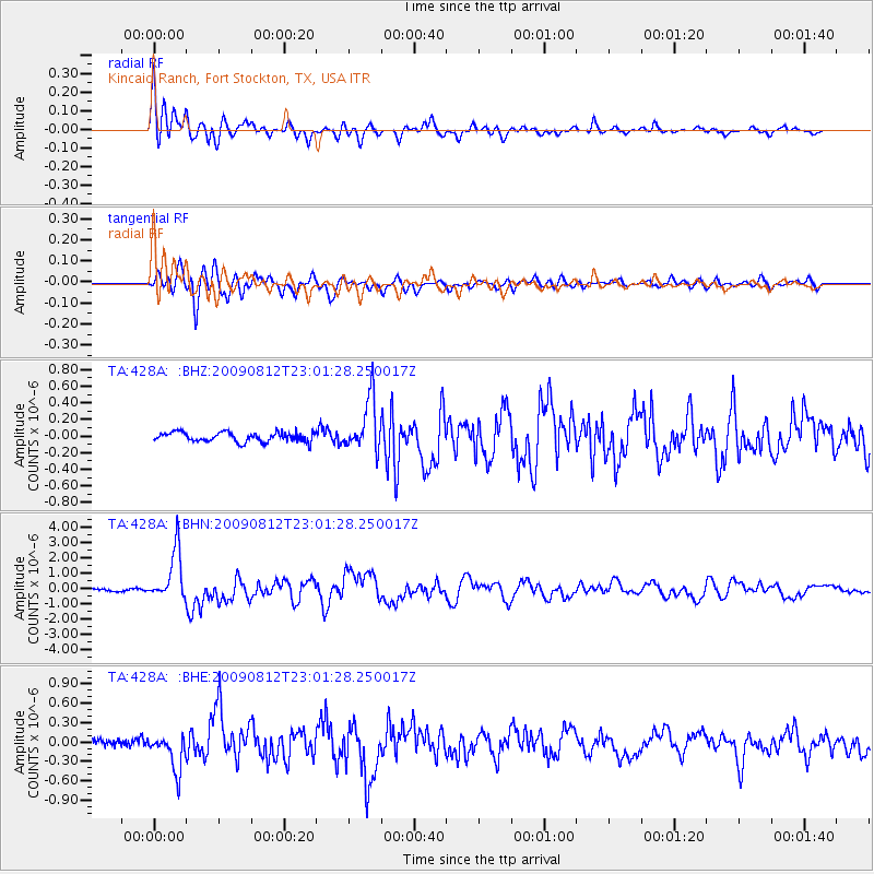
428A Kincaid Ranch, Fort Stockton, TX, USA - Earthquake Result Viewer
| Earthquake location: |
Southeast Of Honshu, Japan |
| Earthquake latitude/longitude: |
32.8/140.4 |
| Earthquake time(UTC): |
2009/08/12 (224) 22:48:51 GMT |
| Earthquake Depth: |
53 km |
| Earthquake Magnitude: |
6.2 MB, 6.6 MW, 6.6 MW |
| Earthquake Catalog/Contributor: |
WHDF/NEIC |
|
| Network: |
TA USArray Transportable Network (new EarthScope stations) |
| Station: |
428A Kincaid Ranch, Fort Stockton, TX, USA |
| Lat/Lon: |
30.73 N/102.68 W |
| Elevation: |
982 m |
|
| Distance: |
93.1 deg |
| Az: |
50.258 deg |
| Baz: |
311.247 deg |
| Ray Param: |
0.041304834 |
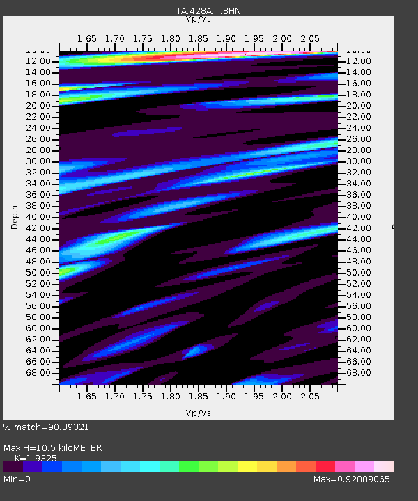
| Estimated Moho Depth: |
10.5 km |
| Estimated Crust Vp/Vs: |
1.93 |
| Assumed Crust Vp: |
6.121 km/s |
| Estimated Crust Vs: |
3.167 km/s |
| Estimated Crust Poisson's Ratio: |
0.32 |
|
| Radial Match: |
90.89321 % |
| Radial Bump: |
400 |
| Transverse Match: |
88.35771 % |
| Transverse Bump: |
400 |
| SOD ConfigId: |
2622 |
| Insert Time: |
2010-03-06 07:37:59.006 +0000 |
| GWidth: |
2.5 |
| Max Bumps: |
400 |
| Tol: |
0.001 |
|
Signal To Noise
| Channel | StoN | STA | LTA |
| TA:428A: :BHN:20090812T23:01:28.250017Z | 19.364979 | 1.624813E-6 | 8.390471E-8 |
| TA:428A: :BHE:20090812T23:01:28.250017Z | 5.11977 | 2.827844E-7 | 5.5233812E-8 |
| TA:428A: :BHZ:20090812T23:01:28.250017Z | 5.481842 | 3.1238693E-7 | 5.698576E-8 |
| Arrivals |
| Ps | 1.6 SECOND |
| PpPs | 4.9 SECOND |
| PsPs/PpSs | 6.6 SECOND |


