You are here: Home > Network List > TA - USArray Transportable Network (new EarthScope stations) Stations List
> Station F26K Sheenjek River, AK, USA > Earthquake Result Viewer
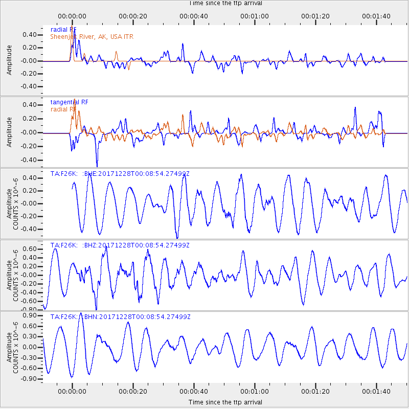
F26K Sheenjek River, AK, USA - Earthquake Result Viewer
*The percent match for this event was below the threshold and hence no stack was calculated.
| Earthquake location: |
South Of Mariana Islands |
| Earthquake latitude/longitude: |
12.0/144.4 |
| Earthquake time(UTC): |
2017/12/27 (361) 23:58:02 GMT |
| Earthquake Depth: |
15 km |
| Earthquake Magnitude: |
5.5 mb |
| Earthquake Catalog/Contributor: |
NEIC PDE/us |
|
| Network: |
TA USArray Transportable Network (new EarthScope stations) |
| Station: |
F26K Sheenjek River, AK, USA |
| Lat/Lon: |
67.69 N/144.15 W |
| Elevation: |
683 m |
|
| Distance: |
71.9 deg |
| Az: |
22.378 deg |
| Baz: |
257.346 deg |
| Ray Param: |
$rayparam |
*The percent match for this event was below the threshold and hence was not used in the summary stack. |
|
| Radial Match: |
61.404457 % |
| Radial Bump: |
400 |
| Transverse Match: |
59.267815 % |
| Transverse Bump: |
400 |
| SOD ConfigId: |
13570011 |
| Insert Time: |
2019-04-29 12:00:02.234 +0000 |
| GWidth: |
2.5 |
| Max Bumps: |
400 |
| Tol: |
0.001 |
|
Signal To Noise
| Channel | StoN | STA | LTA |
| TA:F26K: :BHZ:20171228T00:08:54.27499Z | 0.3871615 | 1.5331254E-7 | 3.959912E-7 |
| TA:F26K: :BHN:20171228T00:08:54.27499Z | 1.3493254 | 6.55368E-7 | 4.8570047E-7 |
| TA:F26K: :BHE:20171228T00:08:54.27499Z | 0.94297385 | 2.4878088E-7 | 2.6382585E-7 |
| Arrivals |
| Ps | |
| PpPs | |
| PsPs/PpSs | |


