You are here: Home > Network List > TA - USArray Transportable Network (new EarthScope stations) Stations List
> Station Q17K Contact Creek, Katmai, AK, USA > Earthquake Result Viewer
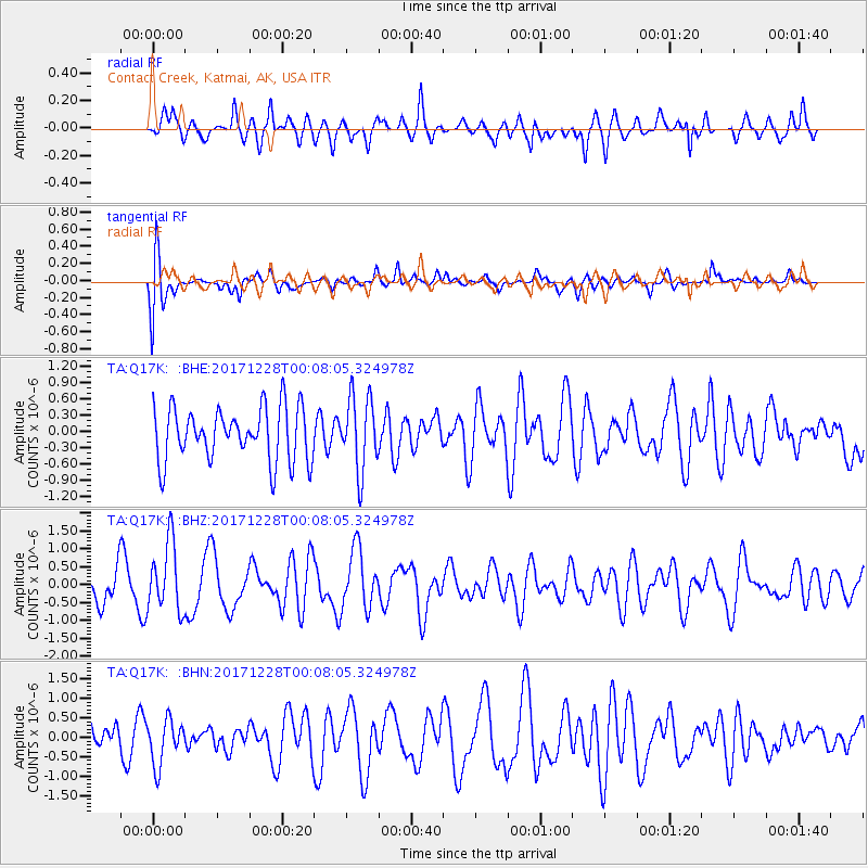
Q17K Contact Creek, Katmai, AK, USA - Earthquake Result Viewer
*The percent match for this event was below the threshold and hence no stack was calculated.
| Earthquake location: |
South Of Mariana Islands |
| Earthquake latitude/longitude: |
12.0/144.4 |
| Earthquake time(UTC): |
2017/12/27 (361) 23:58:02 GMT |
| Earthquake Depth: |
15 km |
| Earthquake Magnitude: |
5.5 mb |
| Earthquake Catalog/Contributor: |
NEIC PDE/us |
|
| Network: |
TA USArray Transportable Network (new EarthScope stations) |
| Station: |
Q17K Contact Creek, Katmai, AK, USA |
| Lat/Lon: |
58.26 N/155.89 W |
| Elevation: |
1165 m |
|
| Distance: |
64.1 deg |
| Az: |
30.49 deg |
| Baz: |
249.905 deg |
| Ray Param: |
$rayparam |
*The percent match for this event was below the threshold and hence was not used in the summary stack. |
|
| Radial Match: |
65.26013 % |
| Radial Bump: |
400 |
| Transverse Match: |
65.77586 % |
| Transverse Bump: |
400 |
| SOD ConfigId: |
13570011 |
| Insert Time: |
2019-04-29 12:00:22.622 +0000 |
| GWidth: |
2.5 |
| Max Bumps: |
400 |
| Tol: |
0.001 |
|
Signal To Noise
| Channel | StoN | STA | LTA |
| TA:Q17K: :BHZ:20171228T00:08:05.324978Z | 2.14257 | 9.604255E-7 | 4.4825865E-7 |
| TA:Q17K: :BHN:20171228T00:08:05.324978Z | 1.5182418 | 5.794887E-7 | 3.8168406E-7 |
| TA:Q17K: :BHE:20171228T00:08:05.324978Z | 1.3742797 | 6.71367E-7 | 4.885228E-7 |
| Arrivals |
| Ps | |
| PpPs | |
| PsPs/PpSs | |


