You are here: Home > Network List > TA - USArray Transportable Network (new EarthScope stations) Stations List
> Station 428A Kincaid Ranch, Fort Stockton, TX, USA > Earthquake Result Viewer
428A Kincaid Ranch, Fort Stockton, TX, USA - Earthquake Result Viewer
| Earthquake location: |
Baffin Bay |
| Earthquake latitude/longitude: |
75.4/-72.5 |
| Earthquake time(UTC): |
2009/07/07 (188) 19:11:46 GMT |
| Earthquake Depth: |
19 km |
| Earthquake Magnitude: |
5.9 MB, 5.7 MS, 6.1 MW, 6.0 MW |
| Earthquake Catalog/Contributor: |
WHDF/NEIC |
|
| Network: |
TA USArray Transportable Network (new EarthScope stations) |
| Station: |
428A Kincaid Ranch, Fort Stockton, TX, USA |
| Lat/Lon: |
30.73 N/102.68 W |
| Elevation: |
982 m |
|
| Distance: |
47.1 deg |
| Az: |
216.305 deg |
| Baz: |
10.078 deg |
| Ray Param: |
0.07020571 |
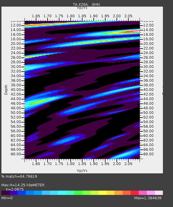
| Estimated Moho Depth: |
14.25 km |
| Estimated Crust Vp/Vs: |
2.10 |
| Assumed Crust Vp: |
6.121 km/s |
| Estimated Crust Vs: |
2.918 km/s |
| Estimated Crust Poisson's Ratio: |
0.35 |
|
| Radial Match: |
84.79619 % |
| Radial Bump: |
400 |
| Transverse Match: |
78.81573 % |
| Transverse Bump: |
400 |
| SOD ConfigId: |
2648 |
| Insert Time: |
2010-03-06 07:38:19.812 +0000 |
| GWidth: |
2.5 |
| Max Bumps: |
400 |
| Tol: |
0.001 |
|

Signal To Noise
| Channel | StoN | STA | LTA |
| TA:428A: :BHN:20090707T19:19:46.324014Z | 5.424071 | 1.5332057E-6 | 2.8266697E-7 |
| TA:428A: :BHE:20090707T19:19:46.324014Z | 5.4875636 | 6.388502E-7 | 1.1641782E-7 |
| TA:428A: :BHZ:20090707T19:19:46.324014Z | 2.7343726 | 1.8610926E-7 | 6.806288E-8 |
| Arrivals |
| Ps | 2.7 SECOND |
| PpPs | 6.9 SECOND |
| PsPs/PpSs | 9.6 SECOND |


