You are here: Home > Network List > TA - USArray Transportable Network (new EarthScope stations) Stations List
> Station 428A Kincaid Ranch, Fort Stockton, TX, USA > Earthquake Result Viewer
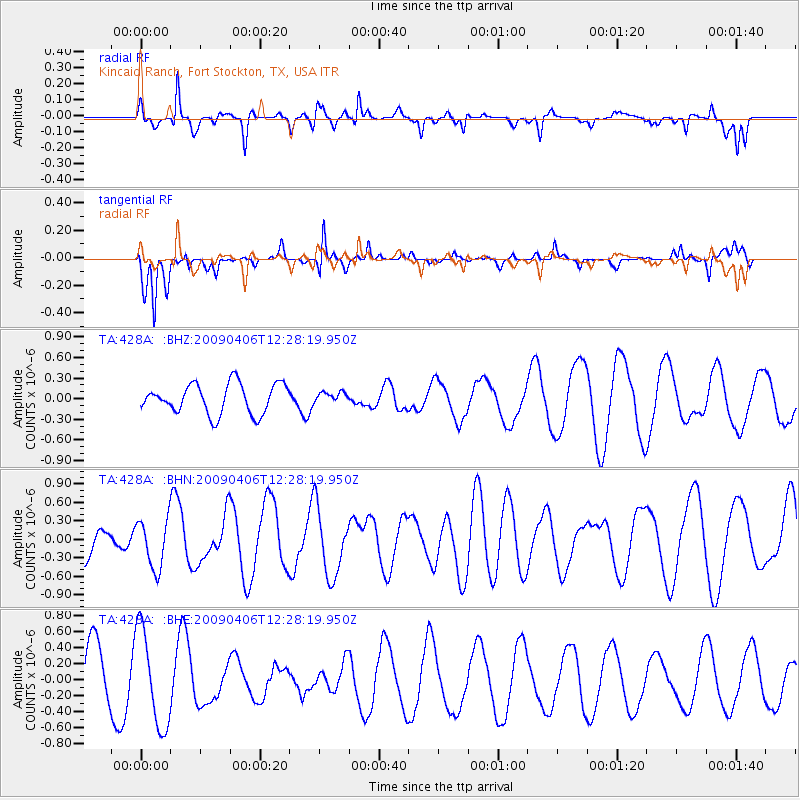
428A Kincaid Ranch, Fort Stockton, TX, USA - Earthquake Result Viewer
*The percent match for this event was below the threshold and hence no stack was calculated.
| Earthquake location: |
Tonga Islands Region |
| Earthquake latitude/longitude: |
-22.4/-174.9 |
| Earthquake time(UTC): |
2009/04/06 (096) 12:16:08 GMT |
| Earthquake Depth: |
35 km |
| Earthquake Magnitude: |
5.5 MS, 5.4 MB |
| Earthquake Catalog/Contributor: |
WHDF/NEIC |
|
| Network: |
TA USArray Transportable Network (new EarthScope stations) |
| Station: |
428A Kincaid Ranch, Fort Stockton, TX, USA |
| Lat/Lon: |
30.73 N/102.68 W |
| Elevation: |
982 m |
|
| Distance: |
87.1 deg |
| Az: |
55.204 deg |
| Baz: |
241.961 deg |
| Ray Param: |
$rayparam |
*The percent match for this event was below the threshold and hence was not used in the summary stack. |
|
| Radial Match: |
77.3949 % |
| Radial Bump: |
400 |
| Transverse Match: |
71.7758 % |
| Transverse Bump: |
309 |
| SOD ConfigId: |
2658 |
| Insert Time: |
2010-03-06 07:38:25.369 +0000 |
| GWidth: |
2.5 |
| Max Bumps: |
400 |
| Tol: |
0.001 |
|
Signal To Noise
| Channel | StoN | STA | LTA |
| TA:428A: :BHN:20090406T12:28:19.950Z | 1.0657872 | 3.969136E-7 | 3.7241355E-7 |
| TA:428A: :BHE:20090406T12:28:19.950Z | 1.5883607 | 6.0095914E-7 | 3.783518E-7 |
| TA:428A: :BHZ:20090406T12:28:19.950Z | 0.3581511 | 7.737358E-8 | 2.1603611E-7 |
| Arrivals |
| Ps | |
| PpPs | |
| PsPs/PpSs | |


