You are here: Home > Network List > TA - USArray Transportable Network (new EarthScope stations) Stations List
> Station 833A Chaparral WMA, Artesia Wells, TX, USA > Earthquake Result Viewer
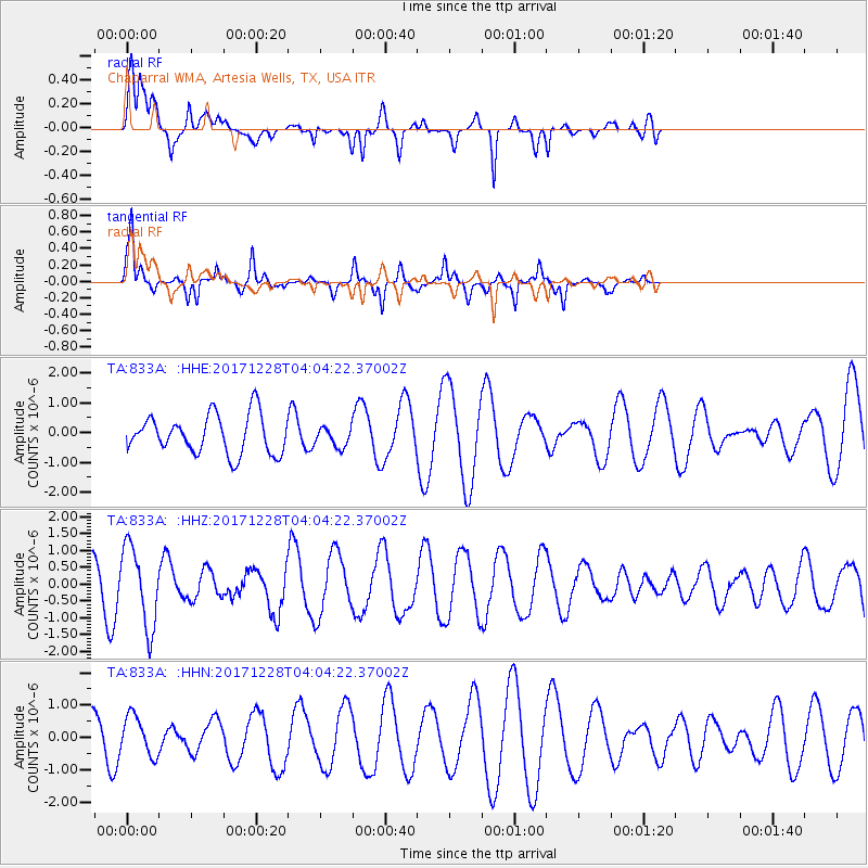
833A Chaparral WMA, Artesia Wells, TX, USA - Earthquake Result Viewer
*The percent match for this event was below the threshold and hence no stack was calculated.
| Earthquake location: |
Near Coast Of Northern Chile |
| Earthquake latitude/longitude: |
-24.9/-70.2 |
| Earthquake time(UTC): |
2017/12/28 (362) 03:54:52 GMT |
| Earthquake Depth: |
53 km |
| Earthquake Magnitude: |
5.5 Mww |
| Earthquake Catalog/Contributor: |
NEIC PDE/us |
|
| Network: |
TA USArray Transportable Network (new EarthScope stations) |
| Station: |
833A Chaparral WMA, Artesia Wells, TX, USA |
| Lat/Lon: |
28.32 N/99.39 W |
| Elevation: |
171 m |
|
| Distance: |
59.9 deg |
| Az: |
330.182 deg |
| Baz: |
149.187 deg |
| Ray Param: |
$rayparam |
*The percent match for this event was below the threshold and hence was not used in the summary stack. |
|
| Radial Match: |
76.72306 % |
| Radial Bump: |
400 |
| Transverse Match: |
86.633095 % |
| Transverse Bump: |
303 |
| SOD ConfigId: |
13570011 |
| Insert Time: |
2019-04-29 12:06:08.143 +0000 |
| GWidth: |
2.5 |
| Max Bumps: |
400 |
| Tol: |
0.001 |
|
Signal To Noise
| Channel | StoN | STA | LTA |
| TA:833A: :HHZ:20171228T04:04:22.37002Z | 3.000153 | 1.1937612E-6 | 3.9790012E-7 |
| TA:833A: :HHN:20171228T04:04:22.37002Z | 0.74591404 | 6.123053E-7 | 8.2087917E-7 |
| TA:833A: :HHE:20171228T04:04:22.37002Z | 0.49388215 | 3.1998948E-7 | 6.479066E-7 |
| Arrivals |
| Ps | |
| PpPs | |
| PsPs/PpSs | |


