You are here: Home > Network List > TA - USArray Transportable Network (new EarthScope stations) Stations List
> Station M16K Timber Creek, AK, USA > Earthquake Result Viewer
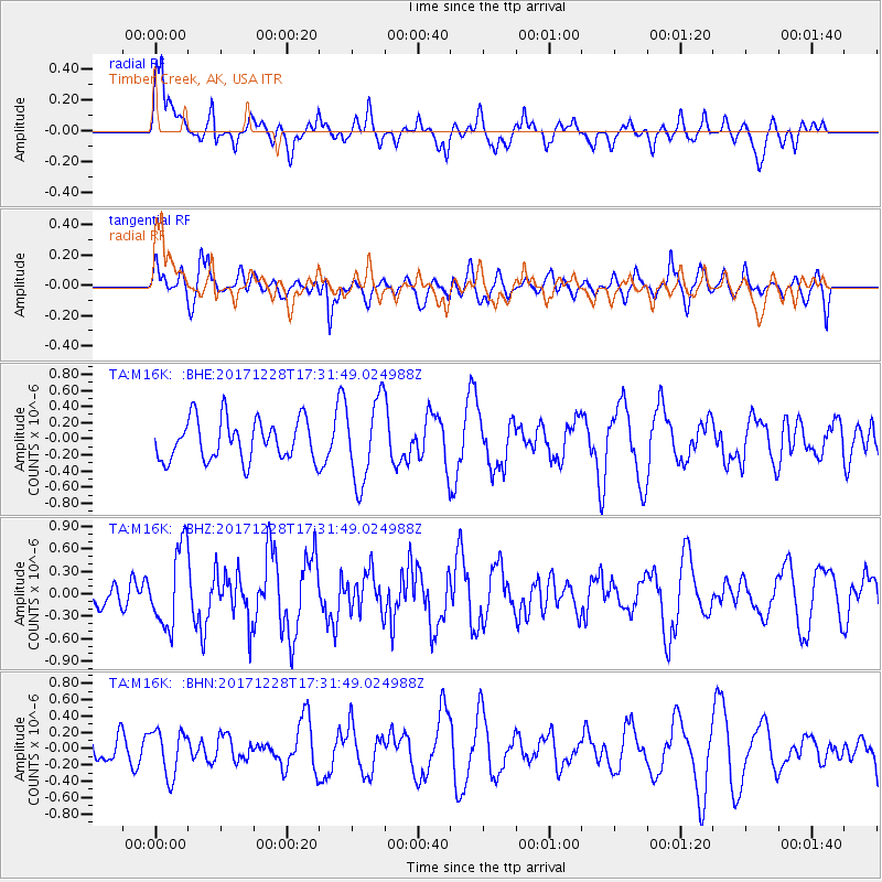
M16K Timber Creek, AK, USA - Earthquake Result Viewer
*The percent match for this event was below the threshold and hence no stack was calculated.
| Earthquake location: |
Talaud Islands, Indonesia |
| Earthquake latitude/longitude: |
4.1/126.8 |
| Earthquake time(UTC): |
2017/12/28 (362) 17:20:19 GMT |
| Earthquake Depth: |
24 km |
| Earthquake Magnitude: |
5.7 Mww |
| Earthquake Catalog/Contributor: |
NEIC PDE/us |
|
| Network: |
TA USArray Transportable Network (new EarthScope stations) |
| Station: |
M16K Timber Creek, AK, USA |
| Lat/Lon: |
61.02 N/158.96 W |
| Elevation: |
394 m |
|
| Distance: |
78.8 deg |
| Az: |
28.536 deg |
| Baz: |
258.114 deg |
| Ray Param: |
$rayparam |
*The percent match for this event was below the threshold and hence was not used in the summary stack. |
|
| Radial Match: |
63.11655 % |
| Radial Bump: |
400 |
| Transverse Match: |
70.596855 % |
| Transverse Bump: |
400 |
| SOD ConfigId: |
13570011 |
| Insert Time: |
2019-04-29 12:10:15.339 +0000 |
| GWidth: |
2.5 |
| Max Bumps: |
400 |
| Tol: |
0.001 |
|
Signal To Noise
| Channel | StoN | STA | LTA |
| TA:M16K: :BHZ:20171228T17:31:49.024988Z | 2.177149 | 5.3467903E-7 | 2.455868E-7 |
| TA:M16K: :BHN:20171228T17:31:49.024988Z | 1.4215592 | 2.7934755E-7 | 1.9650784E-7 |
| TA:M16K: :BHE:20171228T17:31:49.024988Z | 2.0202086 | 5.099859E-7 | 2.524422E-7 |
| Arrivals |
| Ps | |
| PpPs | |
| PsPs/PpSs | |


