You are here: Home > Network List > CI - Caltech Regional Seismic Network Stations List
> Station MPM Manuel Prospect Mine, California, USA > Earthquake Result Viewer
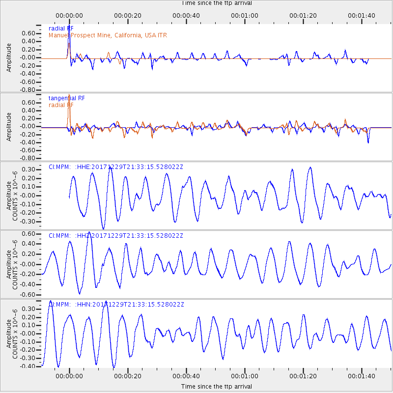
MPM Manuel Prospect Mine, California, USA - Earthquake Result Viewer
*The percent match for this event was below the threshold and hence no stack was calculated.
| Earthquake location: |
Southern East Pacific Rise |
| Earthquake latitude/longitude: |
-53.1/-117.4 |
| Earthquake time(UTC): |
2017/12/29 (363) 21:20:53 GMT |
| Earthquake Depth: |
10 km |
| Earthquake Magnitude: |
5.7 Mww |
| Earthquake Catalog/Contributor: |
NEIC PDE/us |
|
| Network: |
CI Caltech Regional Seismic Network |
| Station: |
MPM Manuel Prospect Mine, California, USA |
| Lat/Lon: |
36.06 N/117.49 W |
| Elevation: |
185 m |
|
| Distance: |
88.8 deg |
| Az: |
359.936 deg |
| Baz: |
179.953 deg |
| Ray Param: |
$rayparam |
*The percent match for this event was below the threshold and hence was not used in the summary stack. |
|
| Radial Match: |
63.067738 % |
| Radial Bump: |
400 |
| Transverse Match: |
38.940857 % |
| Transverse Bump: |
400 |
| SOD ConfigId: |
13570011 |
| Insert Time: |
2019-04-29 12:12:12.296 +0000 |
| GWidth: |
2.5 |
| Max Bumps: |
400 |
| Tol: |
0.001 |
|
Signal To Noise
| Channel | StoN | STA | LTA |
| CI:MPM: :HHZ:20171229T21:33:15.528022Z | 2.8148496 | 3.772067E-7 | 1.3400597E-7 |
| CI:MPM: :HHN:20171229T21:33:15.528022Z | 1.1361573 | 1.8810998E-7 | 1.6556683E-7 |
| CI:MPM: :HHE:20171229T21:33:15.528022Z | 0.82513386 | 1.5088249E-7 | 1.8285819E-7 |
| Arrivals |
| Ps | |
| PpPs | |
| PsPs/PpSs | |


