You are here: Home > Network List > OK - Oklahoma Seismic Network Stations List
> Station X37A Clayton, Oklahoma, USA > Earthquake Result Viewer
X37A Clayton, Oklahoma, USA - Earthquake Result Viewer
| Earthquake location: |
Southern East Pacific Rise |
| Earthquake latitude/longitude: |
-53.1/-117.4 |
| Earthquake time(UTC): |
2017/12/29 (363) 21:20:53 GMT |
| Earthquake Depth: |
10 km |
| Earthquake Magnitude: |
5.7 Mww |
| Earthquake Catalog/Contributor: |
NEIC PDE/us |
|
| Network: |
OK Oklahoma Seismic Network |
| Station: |
X37A Clayton, Oklahoma, USA |
| Lat/Lon: |
34.59 N/95.37 W |
| Elevation: |
207 m |
|
| Distance: |
89.4 deg |
| Az: |
18.035 deg |
| Baz: |
193.081 deg |
| Ray Param: |
0.041877486 |
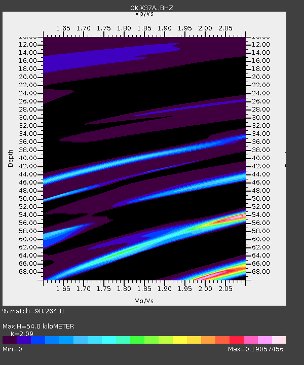
| Estimated Moho Depth: |
54.0 km |
| Estimated Crust Vp/Vs: |
2.09 |
| Assumed Crust Vp: |
6.498 km/s |
| Estimated Crust Vs: |
3.109 km/s |
| Estimated Crust Poisson's Ratio: |
0.35 |
|
| Radial Match: |
98.26431 % |
| Radial Bump: |
88 |
| Transverse Match: |
94.08049 % |
| Transverse Bump: |
151 |
| SOD ConfigId: |
13570011 |
| Insert Time: |
2019-04-29 12:14:12.921 +0000 |
| GWidth: |
2.5 |
| Max Bumps: |
400 |
| Tol: |
0.001 |
|

Signal To Noise
| Channel | StoN | STA | LTA |
| OK:X37A: :BHZ:20171229T21:33:18.424995Z | 0.5691278 | 2.2713475E-6 | 3.990927E-6 |
| OK:X37A: :BHN:20171229T21:33:18.424995Z | 0.6088199 | 2.9778403E-6 | 4.891168E-6 |
| OK:X37A: :BHE:20171229T21:33:18.424995Z | 0.57455313 | 1.6944044E-6 | 2.949082E-6 |
| Arrivals |
| Ps | 9.2 SECOND |
| PpPs | 25 SECOND |
| PsPs/PpSs | 34 SECOND |


