You are here: Home > Network List > S - Seismographs in Schools Projects Stations List
> Station AUBRN Burnie High School, Burnie, TAS > Earthquake Result Viewer
AUBRN Burnie High School, Burnie, TAS - Earthquake Result Viewer
| Earthquake location: |
New Britain Region, P.N.G. |
| Earthquake latitude/longitude: |
-5.4/150.8 |
| Earthquake time(UTC): |
2017/12/29 (363) 23:55:54 GMT |
| Earthquake Depth: |
90 km |
| Earthquake Magnitude: |
5.7 Mww |
| Earthquake Catalog/Contributor: |
NEIC PDE/us |
|
| Network: |
S Seismographs in Schools Projects |
| Station: |
AUBRN Burnie High School, Burnie, TAS |
| Lat/Lon: |
41.04 S/145.87 E |
| Elevation: |
10 m |
|
| Distance: |
35.7 deg |
| Az: |
186.454 deg |
| Baz: |
8.508 deg |
| Ray Param: |
0.07678583 |
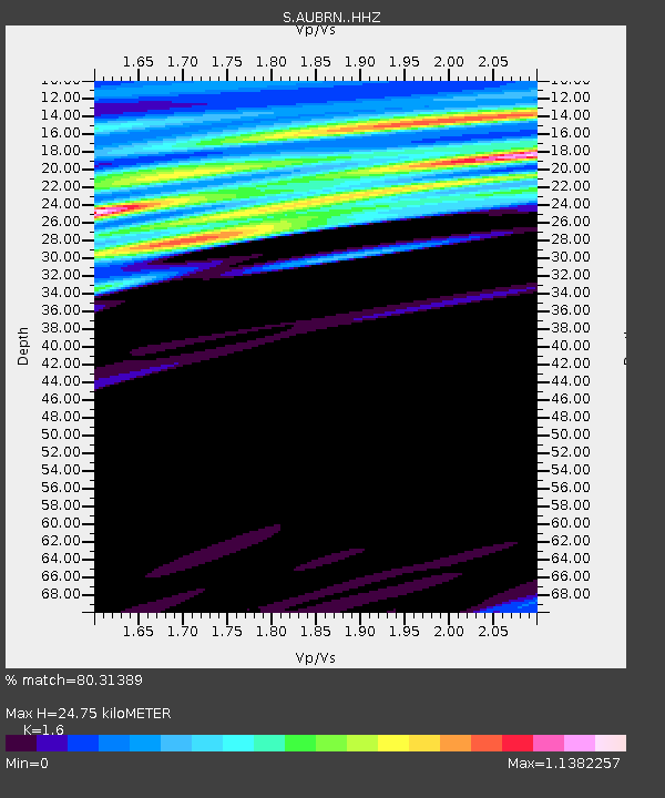
| Estimated Moho Depth: |
24.75 km |
| Estimated Crust Vp/Vs: |
1.60 |
| Assumed Crust Vp: |
6.477 km/s |
| Estimated Crust Vs: |
4.048 km/s |
| Estimated Crust Poisson's Ratio: |
0.18 |
|
| Radial Match: |
80.31389 % |
| Radial Bump: |
400 |
| Transverse Match: |
57.43854 % |
| Transverse Bump: |
400 |
| SOD ConfigId: |
13570011 |
| Insert Time: |
2019-04-29 12:19:42.055 +0000 |
| GWidth: |
2.5 |
| Max Bumps: |
400 |
| Tol: |
0.001 |
|

Signal To Noise
| Channel | StoN | STA | LTA |
| S:AUBRN: :HHZ:20171230T00:02:14.360012Z | 3.9265087 | 2.3728896E-6 | 6.0432563E-7 |
| S:AUBRN: :HHN:20171230T00:02:14.360012Z | 2.6981494 | 1.7339464E-6 | 6.426428E-7 |
| S:AUBRN: :HHE:20171230T00:02:14.360012Z | 1.3712962 | 9.401335E-7 | 6.855802E-7 |
| Arrivals |
| Ps | 2.5 SECOND |
| PpPs | 9.1 SECOND |
| PsPs/PpSs | 12 SECOND |


