You are here: Home > Network List > TA - USArray Transportable Network (new EarthScope stations) Stations List
> Station C16K Lisburne Hills, AK, USA > Earthquake Result Viewer
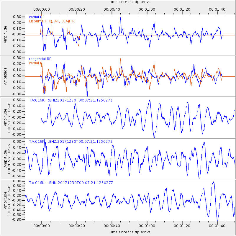
C16K Lisburne Hills, AK, USA - Earthquake Result Viewer
*The percent match for this event was below the threshold and hence no stack was calculated.
| Earthquake location: |
New Britain Region, P.N.G. |
| Earthquake latitude/longitude: |
-5.4/150.8 |
| Earthquake time(UTC): |
2017/12/29 (363) 23:55:54 GMT |
| Earthquake Depth: |
90 km |
| Earthquake Magnitude: |
5.7 Mww |
| Earthquake Catalog/Contributor: |
NEIC PDE/us |
|
| Network: |
TA USArray Transportable Network (new EarthScope stations) |
| Station: |
C16K Lisburne Hills, AK, USA |
| Lat/Lon: |
68.27 N/165.34 W |
| Elevation: |
102 m |
|
| Distance: |
79.6 deg |
| Az: |
15.19 deg |
| Baz: |
224.479 deg |
| Ray Param: |
$rayparam |
*The percent match for this event was below the threshold and hence was not used in the summary stack. |
|
| Radial Match: |
64.81804 % |
| Radial Bump: |
371 |
| Transverse Match: |
57.01204 % |
| Transverse Bump: |
369 |
| SOD ConfigId: |
13570011 |
| Insert Time: |
2019-04-29 12:19:52.200 +0000 |
| GWidth: |
2.5 |
| Max Bumps: |
400 |
| Tol: |
0.001 |
|
Signal To Noise
| Channel | StoN | STA | LTA |
| TA:C16K: :BHZ:20171230T00:07:21.125027Z | 2.6297956 | 4.1888305E-7 | 1.5928349E-7 |
| TA:C16K: :BHN:20171230T00:07:21.125027Z | 1.3492016 | 2.2411203E-7 | 1.6610716E-7 |
| TA:C16K: :BHE:20171230T00:07:21.125027Z | 0.68391806 | 1.3394408E-7 | 1.9584814E-7 |
| Arrivals |
| Ps | |
| PpPs | |
| PsPs/PpSs | |


