You are here: Home > Network List > TA - USArray Transportable Network (new EarthScope stations) Stations List
> Station M11K Mekoryuk, AK, USA > Earthquake Result Viewer
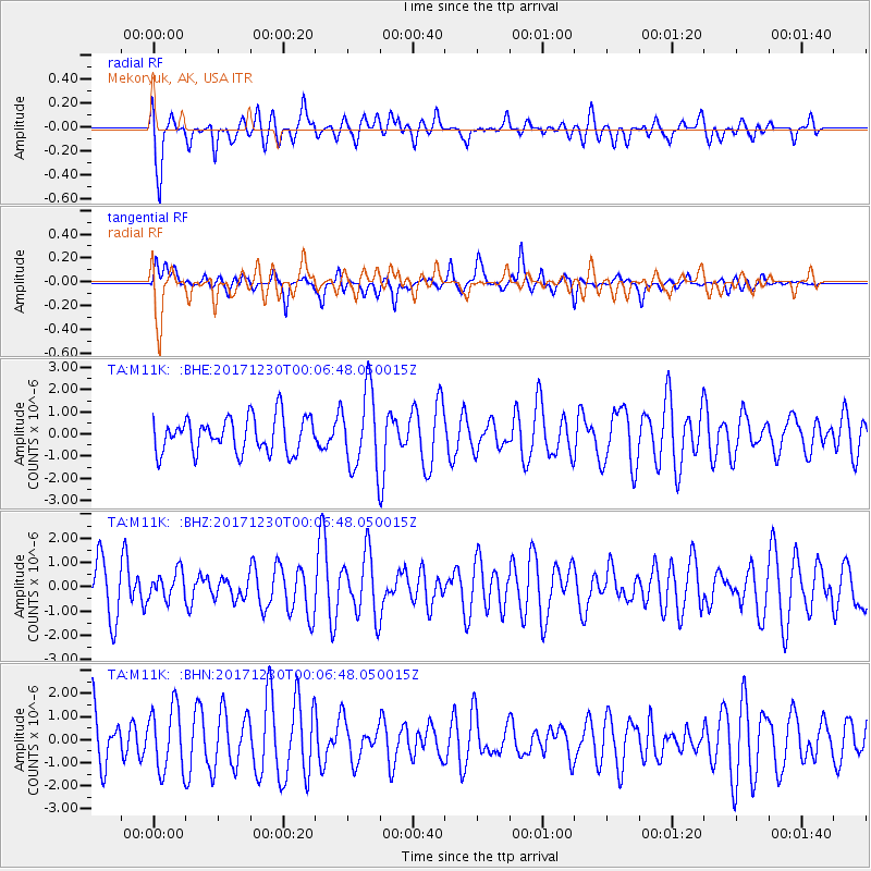
M11K Mekoryuk, AK, USA - Earthquake Result Viewer
*The percent match for this event was below the threshold and hence no stack was calculated.
| Earthquake location: |
New Britain Region, P.N.G. |
| Earthquake latitude/longitude: |
-5.4/150.8 |
| Earthquake time(UTC): |
2017/12/29 (363) 23:55:54 GMT |
| Earthquake Depth: |
90 km |
| Earthquake Magnitude: |
5.7 Mww |
| Earthquake Catalog/Contributor: |
NEIC PDE/us |
|
| Network: |
TA USArray Transportable Network (new EarthScope stations) |
| Station: |
M11K Mekoryuk, AK, USA |
| Lat/Lon: |
60.38 N/166.20 W |
| Elevation: |
3.0 m |
|
| Distance: |
73.7 deg |
| Az: |
20.644 deg |
| Baz: |
224.964 deg |
| Ray Param: |
$rayparam |
*The percent match for this event was below the threshold and hence was not used in the summary stack. |
|
| Radial Match: |
49.087646 % |
| Radial Bump: |
400 |
| Transverse Match: |
49.464767 % |
| Transverse Bump: |
400 |
| SOD ConfigId: |
13570011 |
| Insert Time: |
2019-04-29 12:20:09.809 +0000 |
| GWidth: |
2.5 |
| Max Bumps: |
400 |
| Tol: |
0.001 |
|
Signal To Noise
| Channel | StoN | STA | LTA |
| TA:M11K: :BHZ:20171230T00:06:48.050015Z | 0.57125294 | 5.615843E-7 | 9.830746E-7 |
| TA:M11K: :BHN:20171230T00:06:48.050015Z | 1.4589996 | 1.3906288E-6 | 9.531385E-7 |
| TA:M11K: :BHE:20171230T00:06:48.050015Z | 2.2376869 | 1.7713744E-6 | 7.9160964E-7 |
| Arrivals |
| Ps | |
| PpPs | |
| PsPs/PpSs | |


