You are here: Home > Network List > TA - USArray Transportable Network (new EarthScope stations) Stations List
> Station X23A Hourglass Bar Ranch, Mountainair, NM, USA > Earthquake Result Viewer
X23A Hourglass Bar Ranch, Mountainair, NM, USA - Earthquake Result Viewer
| Earthquake location: |
Kuril Islands |
| Earthquake latitude/longitude: |
46.0/151.5 |
| Earthquake time(UTC): |
2009/04/07 (097) 04:23:33 GMT |
| Earthquake Depth: |
31 km |
| Earthquake Magnitude: |
6.5 MB, 6.8 MS, 6.9 MW, 6.9 MW |
| Earthquake Catalog/Contributor: |
WHDF/NEIC |
|
| Network: |
TA USArray Transportable Network (new EarthScope stations) |
| Station: |
X23A Hourglass Bar Ranch, Mountainair, NM, USA |
| Lat/Lon: |
34.58 N/106.19 W |
| Elevation: |
1948 m |
|
| Distance: |
73.5 deg |
| Az: |
57.218 deg |
| Baz: |
314.794 deg |
| Ray Param: |
0.052893404 |
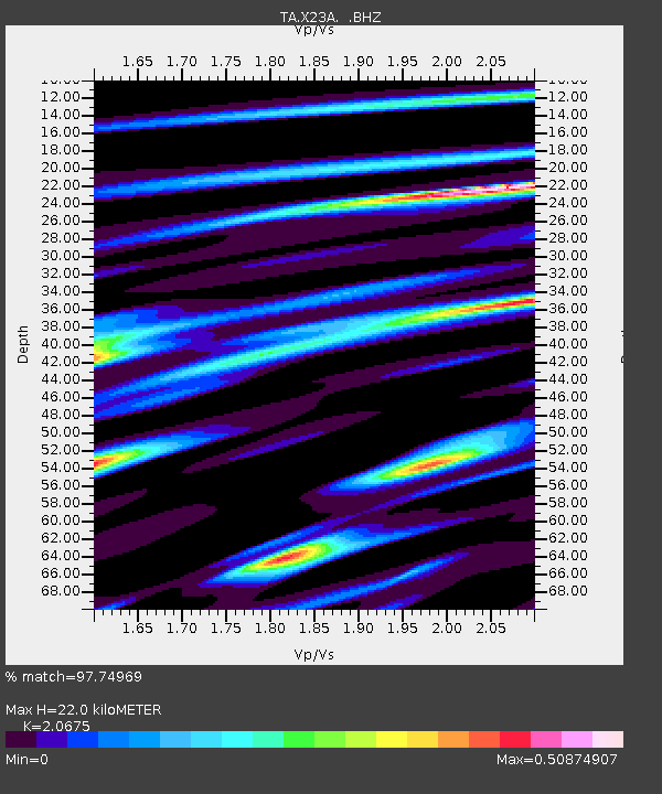
| Estimated Moho Depth: |
22.0 km |
| Estimated Crust Vp/Vs: |
2.07 |
| Assumed Crust Vp: |
6.502 km/s |
| Estimated Crust Vs: |
3.145 km/s |
| Estimated Crust Poisson's Ratio: |
0.35 |
|
| Radial Match: |
97.74969 % |
| Radial Bump: |
363 |
| Transverse Match: |
82.03768 % |
| Transverse Bump: |
400 |
| SOD ConfigId: |
2658 |
| Insert Time: |
2010-03-06 07:40:16.233 +0000 |
| GWidth: |
2.5 |
| Max Bumps: |
400 |
| Tol: |
0.001 |
|
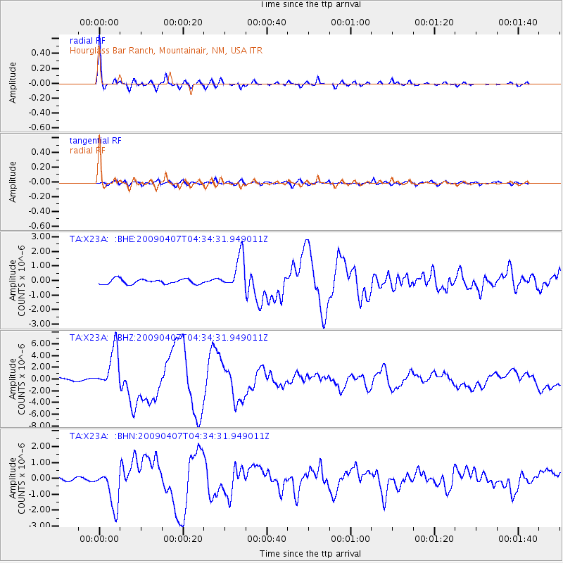
Signal To Noise
| Channel | StoN | STA | LTA |
| TA:X23A: :BHZ:20090407T04:34:31.949011Z | 12.324307 | 3.5466835E-6 | 2.8777956E-7 |
| TA:X23A: :BHN:20090407T04:34:31.949011Z | 12.695574 | 1.2222249E-6 | 9.6271734E-8 |
| TA:X23A: :BHE:20090407T04:34:31.949011Z | 7.1180043 | 1.2147906E-6 | 1.7066449E-7 |
| Arrivals |
| Ps | 3.7 SECOND |
| PpPs | 10 SECOND |
| PsPs/PpSs | 14 SECOND |


