You are here: Home > Network List > G - GEOSCOPE Stations List
> Station NOUC Port Laguerre, New Caledonia > Earthquake Result Viewer
NOUC Port Laguerre, New Caledonia - Earthquake Result Viewer
| Earthquake location: |
Kyushu, Japan |
| Earthquake latitude/longitude: |
32.8/130.7 |
| Earthquake time(UTC): |
2016/04/15 (106) 16:25:06 GMT |
| Earthquake Depth: |
10 km |
| Earthquake Magnitude: |
7.0 MO |
| Earthquake Catalog/Contributor: |
NEIC PDE/NEIC ALERT |
|
| Network: |
G GEOSCOPE |
| Station: |
NOUC Port Laguerre, New Caledonia |
| Lat/Lon: |
22.10 S/166.30 E |
| Elevation: |
112 m |
|
| Distance: |
64.3 deg |
| Az: |
143.213 deg |
| Baz: |
327.047 deg |
| Ray Param: |
0.05901681 |
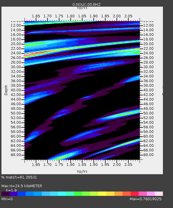
| Estimated Moho Depth: |
24.5 km |
| Estimated Crust Vp/Vs: |
1.60 |
| Assumed Crust Vp: |
5.14 km/s |
| Estimated Crust Vs: |
3.212 km/s |
| Estimated Crust Poisson's Ratio: |
0.18 |
|
| Radial Match: |
91.28531 % |
| Radial Bump: |
341 |
| Transverse Match: |
89.02983 % |
| Transverse Bump: |
386 |
| SOD ConfigId: |
1475611 |
| Insert Time: |
2016-04-29 16:31:18.118 +0000 |
| GWidth: |
2.5 |
| Max Bumps: |
400 |
| Tol: |
0.001 |
|
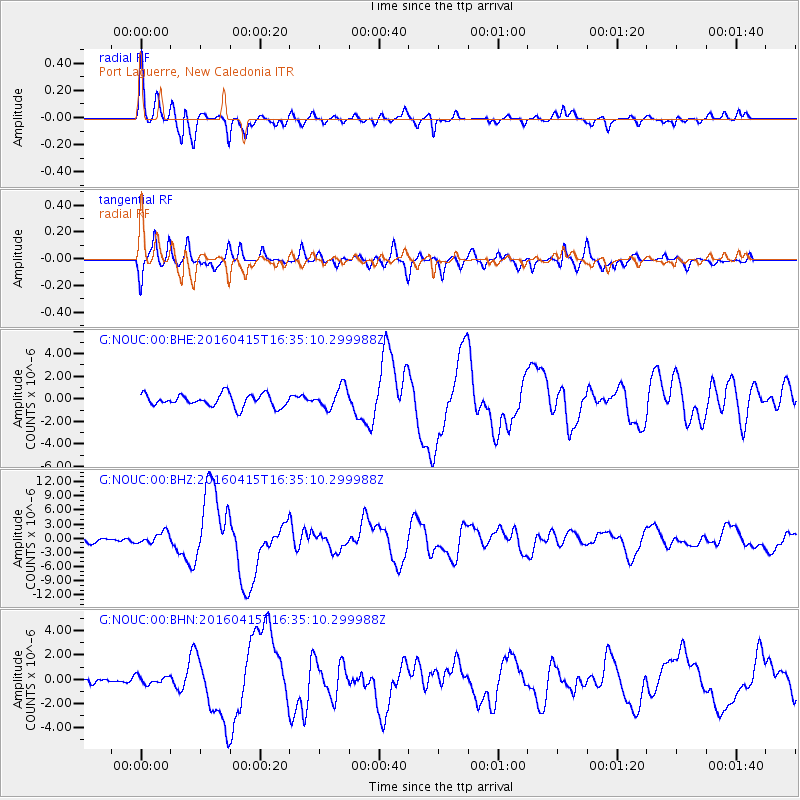
Signal To Noise
| Channel | StoN | STA | LTA |
| G:NOUC:00:BHZ:20160415T16:35:10.299988Z | 2.4232302 | 1.2187674E-6 | 5.0295154E-7 |
| G:NOUC:00:BHN:20160415T16:35:10.299988Z | 0.91414493 | 3.3665094E-7 | 3.6826867E-7 |
| G:NOUC:00:BHE:20160415T16:35:10.299988Z | 1.6796044 | 9.321127E-7 | 5.549597E-7 |
| Arrivals |
| Ps | 2.9 SECOND |
| PpPs | 12 SECOND |
| PsPs/PpSs | 15 SECOND |


