You are here: Home > Network List > TA - USArray Transportable Network (new EarthScope stations) Stations List
> Station X23A Hourglass Bar Ranch, Mountainair, NM, USA > Earthquake Result Viewer
X23A Hourglass Bar Ranch, Mountainair, NM, USA - Earthquake Result Viewer
| Earthquake location: |
Kuril Islands |
| Earthquake latitude/longitude: |
49.9/156.4 |
| Earthquake time(UTC): |
2008/08/04 (217) 04:42:14 GMT |
| Earthquake Depth: |
77 km |
| Earthquake Magnitude: |
5.6 MB, 5.8 MW, 5.7 MW |
| Earthquake Catalog/Contributor: |
WHDF/NEIC |
|
| Network: |
TA USArray Transportable Network (new EarthScope stations) |
| Station: |
X23A Hourglass Bar Ranch, Mountainair, NM, USA |
| Lat/Lon: |
34.58 N/106.19 W |
| Elevation: |
1948 m |
|
| Distance: |
68.8 deg |
| Az: |
61.347 deg |
| Baz: |
316.494 deg |
| Ray Param: |
0.055883463 |
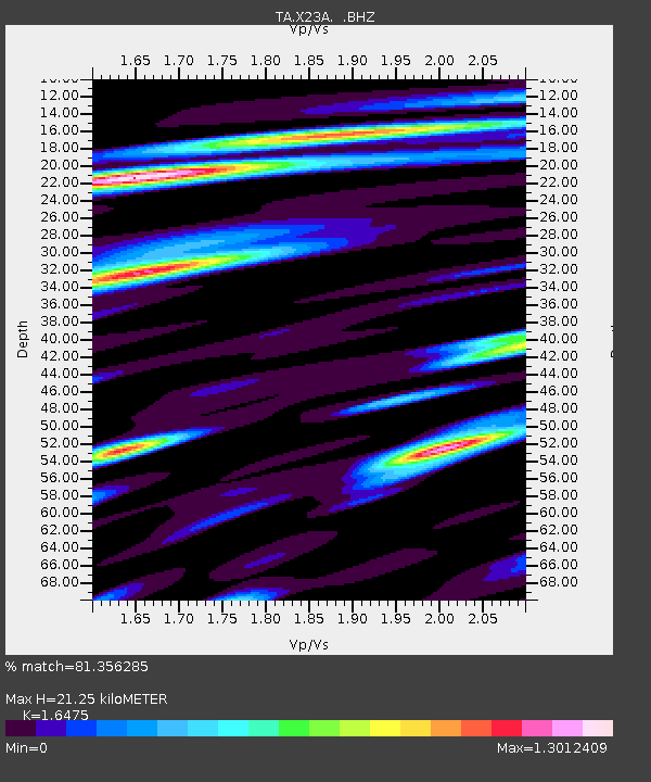
| Estimated Moho Depth: |
21.25 km |
| Estimated Crust Vp/Vs: |
1.65 |
| Assumed Crust Vp: |
6.502 km/s |
| Estimated Crust Vs: |
3.946 km/s |
| Estimated Crust Poisson's Ratio: |
0.21 |
|
| Radial Match: |
81.356285 % |
| Radial Bump: |
400 |
| Transverse Match: |
63.27442 % |
| Transverse Bump: |
400 |
| SOD ConfigId: |
2504 |
| Insert Time: |
2010-03-06 07:41:01.540 +0000 |
| GWidth: |
2.5 |
| Max Bumps: |
400 |
| Tol: |
0.001 |
|

Signal To Noise
| Channel | StoN | STA | LTA |
| TA:X23A: :BHZ:20080804T04:52:40.024011Z | 3.092546 | 2.8093785E-7 | 9.084356E-8 |
| TA:X23A: :BHN:20080804T04:52:40.024011Z | 2.6719322 | 1.2726862E-7 | 4.7631676E-8 |
| TA:X23A: :BHE:20080804T04:52:40.024011Z | 2.2285085 | 1.4511551E-7 | 6.511777E-8 |
| Arrivals |
| Ps | 2.2 SECOND |
| PpPs | 8.3 SECOND |
| PsPs/PpSs | 11 SECOND |


