You are here: Home > Network List > TA - USArray Transportable Network (new EarthScope stations) Stations List
> Station X23A Hourglass Bar Ranch, Mountainair, NM, USA > Earthquake Result Viewer
X23A Hourglass Bar Ranch, Mountainair, NM, USA - Earthquake Result Viewer
| Earthquake location: |
Tonga Islands |
| Earthquake latitude/longitude: |
-21.9/-173.8 |
| Earthquake time(UTC): |
2008/10/19 (293) 05:10:33 GMT |
| Earthquake Depth: |
29 km |
| Earthquake Magnitude: |
6.8 MB, 7.0 MS, 6.9 MW, 6.9 MW |
| Earthquake Catalog/Contributor: |
WHDF/NEIC |
|
| Network: |
TA USArray Transportable Network (new EarthScope stations) |
| Station: |
X23A Hourglass Bar Ranch, Mountainair, NM, USA |
| Lat/Lon: |
34.58 N/106.19 W |
| Elevation: |
1948 m |
|
| Distance: |
85.3 deg |
| Az: |
49.962 deg |
| Baz: |
239.539 deg |
| Ray Param: |
0.04485189 |
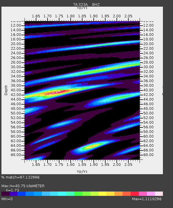
| Estimated Moho Depth: |
40.75 km |
| Estimated Crust Vp/Vs: |
1.73 |
| Assumed Crust Vp: |
6.502 km/s |
| Estimated Crust Vs: |
3.758 km/s |
| Estimated Crust Poisson's Ratio: |
0.25 |
|
| Radial Match: |
97.132996 % |
| Radial Bump: |
400 |
| Transverse Match: |
86.21324 % |
| Transverse Bump: |
400 |
| SOD ConfigId: |
2556 |
| Insert Time: |
2010-03-06 07:41:08.608 +0000 |
| GWidth: |
2.5 |
| Max Bumps: |
400 |
| Tol: |
0.001 |
|

Signal To Noise
| Channel | StoN | STA | LTA |
| TA:X23A: :BHZ:20081019T05:22:36.550015Z | 105.73245 | 7.882784E-6 | 7.4554066E-8 |
| TA:X23A: :BHN:20081019T05:22:36.550015Z | 16.807884 | 1.3905501E-6 | 8.2732015E-8 |
| TA:X23A: :BHE:20081019T05:22:36.550015Z | 38.634476 | 2.5847448E-6 | 6.6902544E-8 |
| Arrivals |
| Ps | 4.7 SECOND |
| PpPs | 17 SECOND |
| PsPs/PpSs | 21 SECOND |


