You are here: Home > Network List > TA - USArray Transportable Network (new EarthScope stations) Stations List
> Station G21K Allakaket, AK, USA > Earthquake Result Viewer
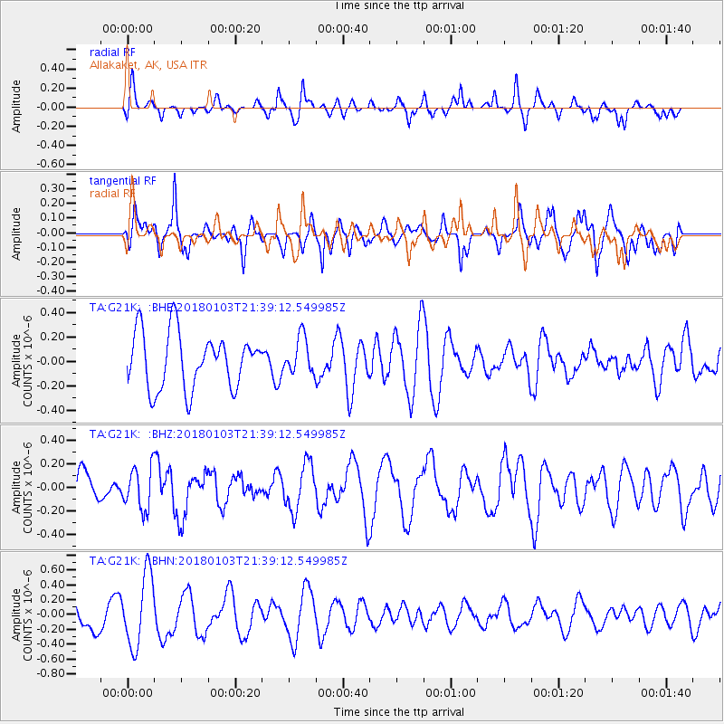
G21K Allakaket, AK, USA - Earthquake Result Viewer
*The percent match for this event was below the threshold and hence no stack was calculated.
| Earthquake location: |
Southeast Of Honshu, Japan |
| Earthquake latitude/longitude: |
29.6/140.5 |
| Earthquake time(UTC): |
2018/01/03 (003) 21:30:21 GMT |
| Earthquake Depth: |
9.5 km |
| Earthquake Magnitude: |
5.5 Mww |
| Earthquake Catalog/Contributor: |
NEIC PDE/us |
|
| Network: |
TA USArray Transportable Network (new EarthScope stations) |
| Station: |
G21K Allakaket, AK, USA |
| Lat/Lon: |
66.52 N/153.51 W |
| Elevation: |
446 m |
|
| Distance: |
53.6 deg |
| Az: |
27.033 deg |
| Baz: |
260.884 deg |
| Ray Param: |
$rayparam |
*The percent match for this event was below the threshold and hence was not used in the summary stack. |
|
| Radial Match: |
43.971222 % |
| Radial Bump: |
351 |
| Transverse Match: |
35.816822 % |
| Transverse Bump: |
334 |
| SOD ConfigId: |
13570011 |
| Insert Time: |
2019-04-29 12:31:47.458 +0000 |
| GWidth: |
2.5 |
| Max Bumps: |
400 |
| Tol: |
0.001 |
|
Signal To Noise
| Channel | StoN | STA | LTA |
| TA:G21K: :BHZ:20180103T21:39:12.549985Z | 1.431859 | 1.7815566E-7 | 1.2442263E-7 |
| TA:G21K: :BHN:20180103T21:39:12.549985Z | 2.0154757 | 4.9180255E-7 | 2.440131E-7 |
| TA:G21K: :BHE:20180103T21:39:12.549985Z | 0.66535676 | 1.513725E-7 | 2.275058E-7 |
| Arrivals |
| Ps | |
| PpPs | |
| PsPs/PpSs | |


