You are here: Home > Network List > TA - USArray Transportable Network (new EarthScope stations) Stations List
> Station X23A Hourglass Bar Ranch, Mountainair, NM, USA > Earthquake Result Viewer
X23A Hourglass Bar Ranch, Mountainair, NM, USA - Earthquake Result Viewer
| Earthquake location: |
Tonga Islands |
| Earthquake latitude/longitude: |
-16.3/-173.5 |
| Earthquake time(UTC): |
2009/10/02 (275) 01:07:39 GMT |
| Earthquake Depth: |
8.0 km |
| Earthquake Magnitude: |
6.1 MB, 6.0 MS, 6.1 MW, 6.1 MW |
| Earthquake Catalog/Contributor: |
WHDF/NEIC |
|
| Network: |
TA USArray Transportable Network (new EarthScope stations) |
| Station: |
X23A Hourglass Bar Ranch, Mountainair, NM, USA |
| Lat/Lon: |
34.58 N/106.19 W |
| Elevation: |
1948 m |
|
| Distance: |
81.5 deg |
| Az: |
50.315 deg |
| Baz: |
243.575 deg |
| Ray Param: |
0.047555014 |
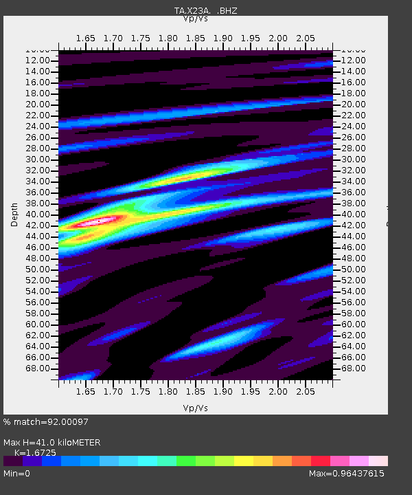
| Estimated Moho Depth: |
41.0 km |
| Estimated Crust Vp/Vs: |
1.67 |
| Assumed Crust Vp: |
6.502 km/s |
| Estimated Crust Vs: |
3.887 km/s |
| Estimated Crust Poisson's Ratio: |
0.22 |
|
| Radial Match: |
92.00097 % |
| Radial Bump: |
275 |
| Transverse Match: |
78.5884 % |
| Transverse Bump: |
400 |
| SOD ConfigId: |
2622 |
| Insert Time: |
2010-03-06 07:42:00.411 +0000 |
| GWidth: |
2.5 |
| Max Bumps: |
400 |
| Tol: |
0.001 |
|

Signal To Noise
| Channel | StoN | STA | LTA |
| TA:X23A: :BHZ:20091002T01:19:25.549001Z | 4.855205 | 4.5190413E-7 | 9.307622E-8 |
| TA:X23A: :BHN:20091002T01:19:25.549001Z | 1.7449715 | 1.5692275E-7 | 8.992855E-8 |
| TA:X23A: :BHE:20091002T01:19:25.549001Z | 1.4248819 | 1.5510122E-7 | 1.0885198E-7 |
| Arrivals |
| Ps | 4.4 SECOND |
| PpPs | 16 SECOND |
| PsPs/PpSs | 21 SECOND |


