You are here: Home > Network List > TA - USArray Transportable Network (new EarthScope stations) Stations List
> Station X23A Hourglass Bar Ranch, Mountainair, NM, USA > Earthquake Result Viewer
X23A Hourglass Bar Ranch, Mountainair, NM, USA - Earthquake Result Viewer
| Earthquake location: |
Azores Islands Region |
| Earthquake latitude/longitude: |
36.2/-33.9 |
| Earthquake time(UTC): |
2009/11/04 (308) 18:41:44 GMT |
| Earthquake Depth: |
10 km |
| Earthquake Magnitude: |
5.7 MB, 5.6 MS, 5.9 MW, 5.8 MW |
| Earthquake Catalog/Contributor: |
WHDF/NEIC |
|
| Network: |
TA USArray Transportable Network (new EarthScope stations) |
| Station: |
X23A Hourglass Bar Ranch, Mountainair, NM, USA |
| Lat/Lon: |
34.58 N/106.19 W |
| Elevation: |
1948 m |
|
| Distance: |
57.7 deg |
| Az: |
291.523 deg |
| Baz: |
65.85 deg |
| Ray Param: |
0.06333992 |
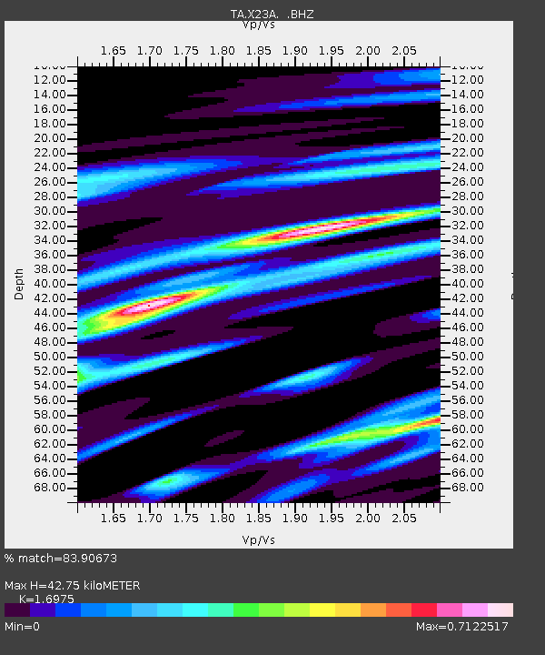
| Estimated Moho Depth: |
42.75 km |
| Estimated Crust Vp/Vs: |
1.70 |
| Assumed Crust Vp: |
6.502 km/s |
| Estimated Crust Vs: |
3.83 km/s |
| Estimated Crust Poisson's Ratio: |
0.23 |
|
| Radial Match: |
83.90673 % |
| Radial Bump: |
368 |
| Transverse Match: |
56.018345 % |
| Transverse Bump: |
400 |
| SOD ConfigId: |
2622 |
| Insert Time: |
2010-03-06 07:42:04.833 +0000 |
| GWidth: |
2.5 |
| Max Bumps: |
400 |
| Tol: |
0.001 |
|

Signal To Noise
| Channel | StoN | STA | LTA |
| TA:X23A: :BHZ:20091104T18:51:03.774001Z | 5.9942546 | 7.428454E-7 | 1.2392623E-7 |
| TA:X23A: :BHN:20091104T18:51:03.774001Z | 1.4696012 | 1.556107E-7 | 1.0588635E-7 |
| TA:X23A: :BHE:20091104T18:51:03.774001Z | 3.564049 | 4.3703017E-7 | 1.2262181E-7 |
| Arrivals |
| Ps | 4.8 SECOND |
| PpPs | 17 SECOND |
| PsPs/PpSs | 22 SECOND |


