You are here: Home > Network List > IW - Intermountain West Stations List
> Station RWWY Rawlins, Wyoming, USA > Earthquake Result Viewer
RWWY Rawlins, Wyoming, USA - Earthquake Result Viewer
| Earthquake location: |
Kyushu, Japan |
| Earthquake latitude/longitude: |
32.8/130.7 |
| Earthquake time(UTC): |
2016/04/15 (106) 16:25:06 GMT |
| Earthquake Depth: |
10 km |
| Earthquake Magnitude: |
7.0 MO |
| Earthquake Catalog/Contributor: |
NEIC PDE/NEIC ALERT |
|
| Network: |
IW Intermountain West |
| Station: |
RWWY Rawlins, Wyoming, USA |
| Lat/Lon: |
41.69 N/107.21 W |
| Elevation: |
2402 m |
|
| Distance: |
88.7 deg |
| Az: |
39.411 deg |
| Baz: |
314.434 deg |
| Ray Param: |
0.04236668 |
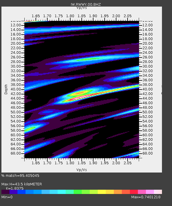
| Estimated Moho Depth: |
43.5 km |
| Estimated Crust Vp/Vs: |
1.84 |
| Assumed Crust Vp: |
6.159 km/s |
| Estimated Crust Vs: |
3.352 km/s |
| Estimated Crust Poisson's Ratio: |
0.29 |
|
| Radial Match: |
95.405045 % |
| Radial Bump: |
348 |
| Transverse Match: |
91.24682 % |
| Transverse Bump: |
328 |
| SOD ConfigId: |
1475611 |
| Insert Time: |
2016-04-29 16:42:41.375 +0000 |
| GWidth: |
2.5 |
| Max Bumps: |
400 |
| Tol: |
0.001 |
|

Signal To Noise
| Channel | StoN | STA | LTA |
| IW:RWWY:00:BHZ:20160415T16:37:28.11499Z | 3.9334905 | 7.172611E-7 | 1.8234724E-7 |
| IW:RWWY:00:BH1:20160415T16:37:28.11499Z | 1.2473947 | 2.733079E-7 | 2.1910299E-7 |
| IW:RWWY:00:BH2:20160415T16:37:28.11499Z | 1.041491 | 2.7922488E-7 | 2.6810108E-7 |
| Arrivals |
| Ps | 6.0 SECOND |
| PpPs | 20 SECOND |
| PsPs/PpSs | 26 SECOND |


