You are here: Home > Network List > GO - National Seismic Network of Georgia Stations List
> Station AKH Akhalkalaki > Earthquake Result Viewer
AKH Akhalkalaki - Earthquake Result Viewer
| Earthquake location: |
Myanmar-India Border Region |
| Earthquake latitude/longitude: |
24.8/94.9 |
| Earthquake time(UTC): |
2018/01/07 (007) 06:47:14 GMT |
| Earthquake Depth: |
23 km |
| Earthquake Magnitude: |
5.5 Mww |
| Earthquake Catalog/Contributor: |
NEIC PDE/us |
|
| Network: |
GO National Seismic Network of Georgia |
| Station: |
AKH Akhalkalaki |
| Lat/Lon: |
41.41 N/43.49 E |
| Elevation: |
1720 m |
|
| Distance: |
45.5 deg |
| Az: |
304.474 deg |
| Baz: |
94.853 deg |
| Ray Param: |
0.071199484 |
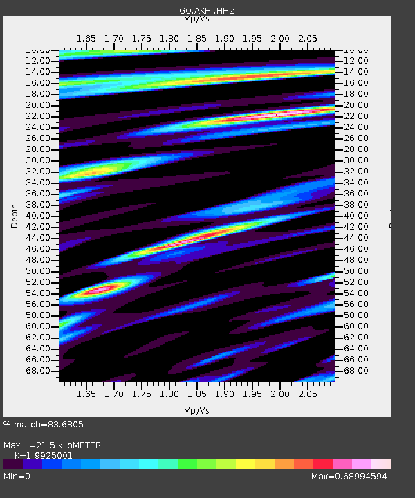
| Estimated Moho Depth: |
21.5 km |
| Estimated Crust Vp/Vs: |
1.99 |
| Assumed Crust Vp: |
6.419 km/s |
| Estimated Crust Vs: |
3.222 km/s |
| Estimated Crust Poisson's Ratio: |
0.33 |
|
| Radial Match: |
83.6805 % |
| Radial Bump: |
399 |
| Transverse Match: |
81.62552 % |
| Transverse Bump: |
400 |
| SOD ConfigId: |
13570011 |
| Insert Time: |
2019-04-29 12:43:30.552 +0000 |
| GWidth: |
2.5 |
| Max Bumps: |
400 |
| Tol: |
0.001 |
|

Signal To Noise
| Channel | StoN | STA | LTA |
| GO:AKH: :HHZ:20180107T06:55:01.129987Z | 40.434875 | 8.030334E-6 | 1.985992E-7 |
| GO:AKH: :HHN:20180107T06:55:01.129987Z | 4.259606 | 1.1006464E-6 | 2.583916E-7 |
| GO:AKH: :HHE:20180107T06:55:01.129987Z | 14.54164 | 3.2443868E-6 | 2.231101E-7 |
| Arrivals |
| Ps | 3.5 SECOND |
| PpPs | 9.5 SECOND |
| PsPs/PpSs | 13 SECOND |


