You are here: Home > Network List > TA - USArray Transportable Network (new EarthScope stations) Stations List
> Station A36M Sachs Harbour, NT, CAN > Earthquake Result Viewer
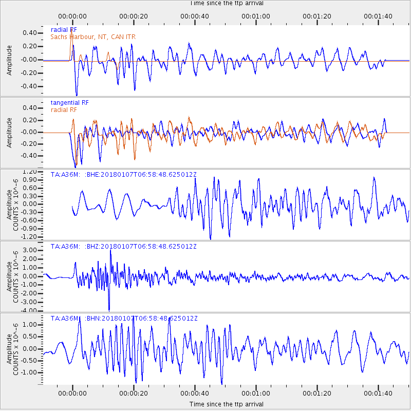
A36M Sachs Harbour, NT, CAN - Earthquake Result Viewer
*The percent match for this event was below the threshold and hence no stack was calculated.
| Earthquake location: |
Myanmar-India Border Region |
| Earthquake latitude/longitude: |
24.8/94.9 |
| Earthquake time(UTC): |
2018/01/07 (007) 06:47:14 GMT |
| Earthquake Depth: |
23 km |
| Earthquake Magnitude: |
5.5 Mww |
| Earthquake Catalog/Contributor: |
NEIC PDE/us |
|
| Network: |
TA USArray Transportable Network (new EarthScope stations) |
| Station: |
A36M Sachs Harbour, NT, CAN |
| Lat/Lon: |
71.99 N/125.25 W |
| Elevation: |
32 m |
|
| Distance: |
79.7 deg |
| Az: |
11.769 deg |
| Baz: |
323.413 deg |
| Ray Param: |
$rayparam |
*The percent match for this event was below the threshold and hence was not used in the summary stack. |
|
| Radial Match: |
71.626015 % |
| Radial Bump: |
400 |
| Transverse Match: |
79.823975 % |
| Transverse Bump: |
400 |
| SOD ConfigId: |
13570011 |
| Insert Time: |
2019-04-29 12:45:03.319 +0000 |
| GWidth: |
2.5 |
| Max Bumps: |
400 |
| Tol: |
0.001 |
|
Signal To Noise
| Channel | StoN | STA | LTA |
| TA:A36M: :BHZ:20180107T06:58:48.625012Z | 1.9523851 | 6.454498E-7 | 3.3059555E-7 |
| TA:A36M: :BHN:20180107T06:58:48.625012Z | 1.839415 | 5.59035E-7 | 3.0392002E-7 |
| TA:A36M: :BHE:20180107T06:58:48.625012Z | 0.9320275 | 2.5313722E-7 | 2.7159845E-7 |
| Arrivals |
| Ps | |
| PpPs | |
| PsPs/PpSs | |


