You are here: Home > Network List > TA - USArray Transportable Network (new EarthScope stations) Stations List
> Station D25K Kavik River, AK, USA > Earthquake Result Viewer
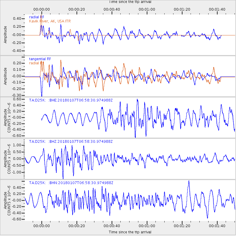
D25K Kavik River, AK, USA - Earthquake Result Viewer
*The percent match for this event was below the threshold and hence no stack was calculated.
| Earthquake location: |
Myanmar-India Border Region |
| Earthquake latitude/longitude: |
24.8/94.9 |
| Earthquake time(UTC): |
2018/01/07 (007) 06:47:14 GMT |
| Earthquake Depth: |
23 km |
| Earthquake Magnitude: |
5.5 Mww |
| Earthquake Catalog/Contributor: |
NEIC PDE/us |
|
| Network: |
TA USArray Transportable Network (new EarthScope stations) |
| Station: |
D25K Kavik River, AK, USA |
| Lat/Lon: |
69.32 N/146.38 W |
| Elevation: |
770 m |
|
| Distance: |
76.5 deg |
| Az: |
18.689 deg |
| Baz: |
304.897 deg |
| Ray Param: |
$rayparam |
*The percent match for this event was below the threshold and hence was not used in the summary stack. |
|
| Radial Match: |
75.65221 % |
| Radial Bump: |
400 |
| Transverse Match: |
65.83465 % |
| Transverse Bump: |
400 |
| SOD ConfigId: |
13570011 |
| Insert Time: |
2019-04-29 12:45:08.859 +0000 |
| GWidth: |
2.5 |
| Max Bumps: |
400 |
| Tol: |
0.001 |
|
Signal To Noise
| Channel | StoN | STA | LTA |
| TA:D25K: :BHZ:20180107T06:58:30.974988Z | 2.769111 | 4.562265E-7 | 1.6475559E-7 |
| TA:D25K: :BHN:20180107T06:58:30.974988Z | 2.2481692 | 2.281203E-7 | 1.0146937E-7 |
| TA:D25K: :BHE:20180107T06:58:30.974988Z | 1.6082605 | 2.1625748E-7 | 1.344667E-7 |
| Arrivals |
| Ps | |
| PpPs | |
| PsPs/PpSs | |


