You are here: Home > Network List > CI - Caltech Regional Seismic Network Stations List
> Station MPM Manuel Prospect Mine, California, USA > Earthquake Result Viewer
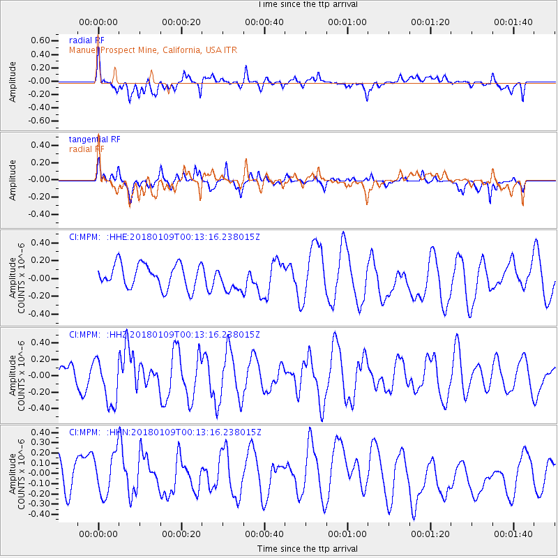
MPM Manuel Prospect Mine, California, USA - Earthquake Result Viewer
*The percent match for this event was below the threshold and hence no stack was calculated.
| Earthquake location: |
Galapagos Islands Region |
| Earthquake latitude/longitude: |
1.7/-90.8 |
| Earthquake time(UTC): |
2018/01/09 (009) 00:05:54 GMT |
| Earthquake Depth: |
10 km |
| Earthquake Magnitude: |
5.8 Mww |
| Earthquake Catalog/Contributor: |
NEIC PDE/us |
|
| Network: |
CI Caltech Regional Seismic Network |
| Station: |
MPM Manuel Prospect Mine, California, USA |
| Lat/Lon: |
36.06 N/117.49 W |
| Elevation: |
185 m |
|
| Distance: |
42.2 deg |
| Az: |
327.221 deg |
| Baz: |
138.097 deg |
| Ray Param: |
$rayparam |
*The percent match for this event was below the threshold and hence was not used in the summary stack. |
|
| Radial Match: |
53.679184 % |
| Radial Bump: |
400 |
| Transverse Match: |
47.72283 % |
| Transverse Bump: |
258 |
| SOD ConfigId: |
13570011 |
| Insert Time: |
2019-04-29 12:47:46.479 +0000 |
| GWidth: |
2.5 |
| Max Bumps: |
400 |
| Tol: |
0.001 |
|
Signal To Noise
| Channel | StoN | STA | LTA |
| CI:MPM: :HHZ:20180109T00:13:16.238015Z | 2.503367 | 2.839107E-7 | 1.13411545E-7 |
| CI:MPM: :HHN:20180109T00:13:16.238015Z | 1.8076333 | 2.1189534E-7 | 1.1722253E-7 |
| CI:MPM: :HHE:20180109T00:13:16.238015Z | 1.0944062 | 1.4471556E-7 | 1.3223203E-7 |
| Arrivals |
| Ps | |
| PpPs | |
| PsPs/PpSs | |


