You are here: Home > Network List > CI - Caltech Regional Seismic Network Stations List
> Station MPP McPhearson Peak > Earthquake Result Viewer
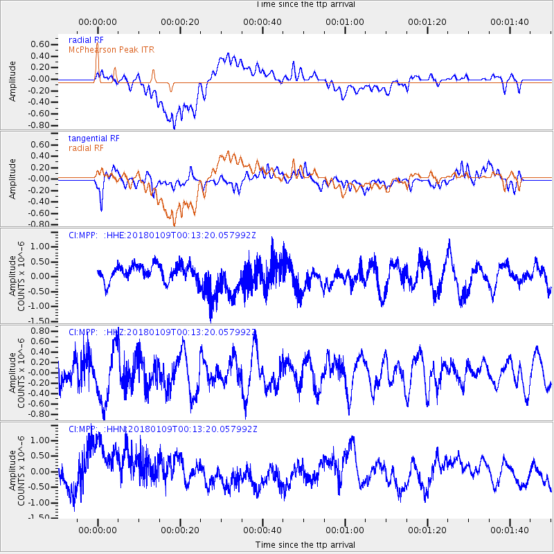
MPP McPhearson Peak - Earthquake Result Viewer
*The percent match for this event was below the threshold and hence no stack was calculated.
| Earthquake location: |
Galapagos Islands Region |
| Earthquake latitude/longitude: |
1.7/-90.8 |
| Earthquake time(UTC): |
2018/01/09 (009) 00:05:54 GMT |
| Earthquake Depth: |
10 km |
| Earthquake Magnitude: |
5.8 Mww |
| Earthquake Catalog/Contributor: |
NEIC PDE/us |
|
| Network: |
CI Caltech Regional Seismic Network |
| Station: |
MPP McPhearson Peak |
| Lat/Lon: |
34.89 N/119.81 W |
| Elevation: |
1739 m |
|
| Distance: |
42.7 deg |
| Az: |
323.994 deg |
| Baz: |
134.372 deg |
| Ray Param: |
$rayparam |
*The percent match for this event was below the threshold and hence was not used in the summary stack. |
|
| Radial Match: |
37.685078 % |
| Radial Bump: |
400 |
| Transverse Match: |
50.961308 % |
| Transverse Bump: |
400 |
| SOD ConfigId: |
13570011 |
| Insert Time: |
2019-04-29 12:47:47.308 +0000 |
| GWidth: |
2.5 |
| Max Bumps: |
400 |
| Tol: |
0.001 |
|
Signal To Noise
| Channel | StoN | STA | LTA |
| CI:MPP: :HHZ:20180109T00:13:20.057992Z | 2.7609565 | 5.15529E-7 | 1.8672117E-7 |
| CI:MPP: :HHN:20180109T00:13:20.057992Z | 4.611817 | 1.1795375E-6 | 2.557642E-7 |
| CI:MPP: :HHE:20180109T00:13:20.057992Z | 2.3631382 | 6.165444E-7 | 2.6090072E-7 |
| Arrivals |
| Ps | |
| PpPs | |
| PsPs/PpSs | |


