You are here: Home > Network List > TA - USArray Transportable Network (new EarthScope stations) Stations List
> Station MSTX Muleshoe, TX, USA > Earthquake Result Viewer
MSTX Muleshoe, TX, USA - Earthquake Result Viewer

| Earthquake location: |
Kuril Islands |
| Earthquake latitude/longitude: |
50.8/155.0 |
| Earthquake time(UTC): |
2009/04/21 (111) 05:26:11 GMT |
| Earthquake Depth: |
152 km |
| Earthquake Magnitude: |
6.0 MB, 6.2 MW, 6.2 MW |
| Earthquake Catalog/Contributor: |
WHDF/NEIC |
|
| Network: |
TA USArray Transportable Network (new EarthScope stations) |
| Station: |
MSTX Muleshoe, TX, USA |
| Lat/Lon: |
33.97 N/102.77 W |
| Elevation: |
1167 m |
|
| Distance: |
71.4 deg |
| Az: |
58.967 deg |
| Baz: |
319.17 deg |
| Ray Param: |
0.053930707 |
| Estimated Moho Depth: |
33.75 km |
| Estimated Crust Vp/Vs: |
2.06 |
| Assumed Crust Vp: |
6.129 km/s |
| Estimated Crust Vs: |
2.982 km/s |
| Estimated Crust Poisson's Ratio: |
0.34 |
|
| Radial Match: |
90.17435 % |
| Radial Bump: |
395 |
| Transverse Match: |
65.47015 % |
| Transverse Bump: |
400 |
| SOD ConfigId: |
2760 |
| Insert Time: |
2010-03-06 07:44:52.995 +0000 |
| GWidth: |
2.5 |
| Max Bumps: |
400 |
| Tol: |
0.001 |
|
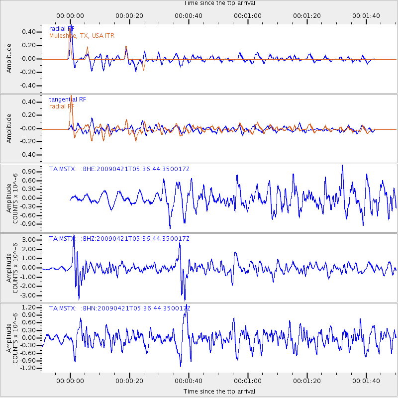
Signal To Noise
| Channel | StoN | STA | LTA |
| TA:MSTX: :BHZ:20090421T05:36:44.350017Z | 8.915599 | 1.494034E-6 | 1.6757528E-7 |
| TA:MSTX: :BHN:20090421T05:36:44.350017Z | 2.9102693 | 3.9926408E-7 | 1.3719145E-7 |
| TA:MSTX: :BHE:20090421T05:36:44.350017Z | 2.7878947 | 4.1629957E-7 | 1.49324E-7 |
| Arrivals |
| Ps | 6.0 SECOND |
| PpPs | 16 SECOND |
| PsPs/PpSs | 22 SECOND |


