You are here: Home > Network List > AV - Alaska Volcano Observatory Stations List
> Station AMKA Regional Station, Amchitka Island, Alaska > Earthquake Result Viewer
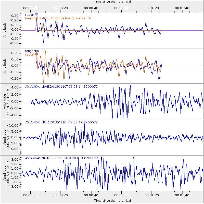
AMKA Regional Station, Amchitka Island, Alaska - Earthquake Result Viewer
*The percent match for this event was below the threshold and hence no stack was calculated.
| Earthquake location: |
North Of Honduras |
| Earthquake latitude/longitude: |
17.5/-83.6 |
| Earthquake time(UTC): |
2018/01/10 (010) 02:51:31 GMT |
| Earthquake Depth: |
33 km |
| Earthquake Magnitude: |
7.8 Mi |
| Earthquake Catalog/Contributor: |
NEIC PDE/pt |
|
| Network: |
AV Alaska Volcano Observatory |
| Station: |
AMKA Regional Station, Amchitka Island, Alaska |
| Lat/Lon: |
51.38 N/179.30 E |
| Elevation: |
116 m |
|
| Distance: |
80.9 deg |
| Az: |
320.961 deg |
| Baz: |
73.539 deg |
| Ray Param: |
$rayparam |
*The percent match for this event was below the threshold and hence was not used in the summary stack. |
|
| Radial Match: |
82.13653 % |
| Radial Bump: |
400 |
| Transverse Match: |
79.29367 % |
| Transverse Bump: |
400 |
| SOD ConfigId: |
13570011 |
| Insert Time: |
2019-04-29 12:55:10.334 +0000 |
| GWidth: |
2.5 |
| Max Bumps: |
400 |
| Tol: |
0.001 |
|
Signal To Noise
| Channel | StoN | STA | LTA |
| AV:AMKA: :BHZ:20180110T03:03:14.820007Z | 0.9671665 | 5.42493E-7 | 5.6090965E-7 |
| AV:AMKA: :BHN:20180110T03:03:14.820007Z | 0.749337 | 4.0988397E-7 | 5.4699547E-7 |
| AV:AMKA: :BHE:20180110T03:03:14.820007Z | 1.1363808 | 5.102597E-7 | 4.4902177E-7 |
| Arrivals |
| Ps | |
| PpPs | |
| PsPs/PpSs | |


