You are here: Home > Network List > UU - University of Utah Regional Network Stations List
> Station CTU Camp Tracy, UT, USA > Earthquake Result Viewer
CTU Camp Tracy, UT, USA - Earthquake Result Viewer
| Earthquake location: |
Kyushu, Japan |
| Earthquake latitude/longitude: |
32.8/130.7 |
| Earthquake time(UTC): |
2016/04/15 (106) 16:25:06 GMT |
| Earthquake Depth: |
10 km |
| Earthquake Magnitude: |
7.0 MO |
| Earthquake Catalog/Contributor: |
NEIC PDE/NEIC ALERT |
|
| Network: |
UU University of Utah Regional Network |
| Station: |
CTU Camp Tracy, UT, USA |
| Lat/Lon: |
40.69 N/111.75 W |
| Elevation: |
1731 m |
|
| Distance: |
86.9 deg |
| Az: |
42.478 deg |
| Baz: |
311.571 deg |
| Ray Param: |
0.04371067 |
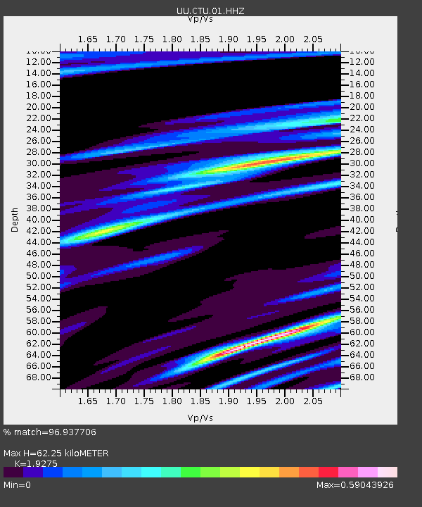
| Estimated Moho Depth: |
62.25 km |
| Estimated Crust Vp/Vs: |
1.93 |
| Assumed Crust Vp: |
6.155 km/s |
| Estimated Crust Vs: |
3.193 km/s |
| Estimated Crust Poisson's Ratio: |
0.32 |
|
| Radial Match: |
96.937706 % |
| Radial Bump: |
273 |
| Transverse Match: |
81.32596 % |
| Transverse Bump: |
400 |
| SOD ConfigId: |
1475611 |
| Insert Time: |
2016-04-29 16:51:45.444 +0000 |
| GWidth: |
2.5 |
| Max Bumps: |
400 |
| Tol: |
0.001 |
|

Signal To Noise
| Channel | StoN | STA | LTA |
| UU:CTU:01:HHZ:20160415T16:37:19.369995Z | 3.0249882 | 1.5044476E-8 | 4.9734E-9 |
| UU:CTU:01:HHN:20160415T16:37:19.369995Z | 1.09916 | 7.3324475E-9 | 6.670956E-9 |
| UU:CTU:01:HHE:20160415T16:37:19.369995Z | 1.2898316 | 5.9928293E-9 | 4.6462105E-9 |
| Arrivals |
| Ps | 9.6 SECOND |
| PpPs | 29 SECOND |
| PsPs/PpSs | 39 SECOND |


